Piloña night lights from space
Night Light of Piloña (Asturias) from space (Spain) Src. Average luminocity for 10x10km area is 2.7365% and for 50x50km: 5.9315%.
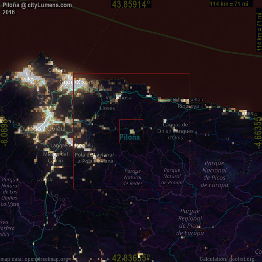
Analysis of Piloña night lights 2016
Square area 10x10 km:
 0%
0%90-99
0%80-89
0%70-79
1.59%60-69
0.63%50-59
0.95%40-49
0.63%30-39
0%20-29
0%10-19
0%0-9
96.19%Square area 50x50 km:
0.64%90-99
0.85%80-89
0.25%70-79
0.49%60-69
0.61%50-59
1.4%40-49
0.72%30-39
1.6%20-29
2.41%10-19
3.84%0-9
87.19%Clear (daylight) street map image can be seen on geolist.org.
Map coordinates:
43° 51' 32.9" North, 6° 4' 11.3" West
43° 21' 0" North, 5° 22' 0" West
42° 50' 11.6" North, 4° 39' 48.8" West
Some cities around Piloña sort by population:
• Sama
26.4 km =16.4 mi,  256°
256°
• Villaviciosa
15.6 km =9.7 mi,  339°
339°
• Pola de Laviana
19.7 km =12.2 mi,  233°
233°
• Pola de Siero
24.4 km =15.2 mi,  281°
281°
• El entrego
23 km =14.3 mi,  252°
252°
• Cangas de Onís
19.2 km =11.9 mi,  89°
89°
• Ribadesella
27.7 km =17.2 mi,  63°
63°
• Parres
17.5 km =10.9 mi, 90°
3113555 (p: 8,389)
Sources (retrieved 2019-11-25):
» Earth at Night: Flat Maps 2012, 2016