Onil night lights from space
Night Light of Onil (Valencia) from space (Spain) Src. Average luminocity for 10x10km area is 15.6786% and for 50x50km: 12.5121%.
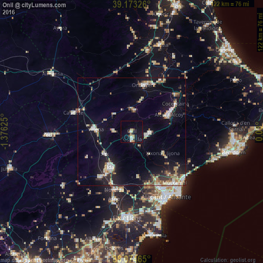
Analysis of Onil night lights 2016
Square area 10x10 km:
100  2.44%
2.44%
90-99 1.46%
80-89 3.25%
70-79 1.46%
60-69 2.11%
50-59 0.81%
40-49 0.81%
30-39 0.81%
20-29 0.49%
10-19 15.75%
0-9 70.62%
2.44%90-99
1.46%80-89
3.25%70-79
1.46%60-69
2.11%50-59
0.81%40-49
0.81%30-39
0.81%20-29
0.49%10-19
15.75%0-9
70.62%Square area 50x50 km:
100 1.49%
90-99 2.23%
80-89 1.85%
70-79 1.26%
60-69 1.35%
50-59 1.15%
40-49 1.03%
30-39 1.53%
20-29 2.78%
10-19 9.47%
0-9 75.86%
1.49%90-99
2.23%80-89
1.85%70-79
1.26%60-69
1.35%50-59
1.15%40-49
1.03%30-39
1.53%20-29
2.78%10-19
9.47%0-9
75.86%Clear (daylight) street map image can be seen on geolist.org.
Map coordinates:
39° 10' 23.7" North, 1° 22' 34.5" West
38° 37' 33.8" North, 0° 40' 23.3" West
38° 4' 28.7" North, 0° 1' 48" East
Some cities around Onil sort by population:
• Alcoy
19.4 km =12.1 mi,  62°
62°
• Elda
19.4 km =12.1 mi,  212°
212°
• Ontinyent
22.5 km =14 mi,  14°
14°
• Villena
16.8 km =10.4 mi,  274°
274°
• Ibi
8.8 km =5.5 mi,  90°
90°
• Castalla
3.2 km =2 mi,  178°
178°
• Sax
16 km =9.9 mi,  231°
231°
• Jijona
17.6 km =10.9 mi,  122°
122°
2513113 (p: 7,474)
Sources (retrieved 2019-11-25):
» Earth at Night: Flat Maps 2012, 2016