Villena night lights from space
Night Light of Villena (Valencia) from space (Spain) Src. Average luminocity for 10x10km area is 19.1153% and for 50x50km: 7.665%.
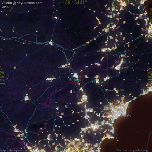
Analysis of Villena night lights 2016
Square area 10x10 km:
100  2.44%
2.44%
90-99 5.19%
80-89 2.92%
70-79 1.46%
60-69 0.81%
50-59 0.65%
40-49 0.49%
30-39 1.95%
20-29 2.6%
10-19 13.96%
0-9 67.53%
2.44%90-99
5.19%80-89
2.92%70-79
1.46%60-69
0.81%50-59
0.65%40-49
0.49%30-39
1.95%20-29
2.6%10-19
13.96%0-9
67.53%Square area 50x50 km:
100 1.03%
90-99 1.53%
80-89 1.08%
70-79 0.56%
60-69 0.7%
50-59 0.44%
40-49 0.42%
30-39 0.91%
20-29 1.59%
10-19 5.34%
0-9 86.41%
1.03%90-99
1.53%80-89
1.08%70-79
0.56%60-69
0.7%50-59
0.44%40-49
0.42%30-39
0.91%20-29
1.59%10-19
5.34%0-9
86.41%Clear (daylight) street map image can be seen on geolist.org.
Map coordinates:
39° 11' 3.9" North, 1° 34' 7.7" West
38° 38' 14.3" North, 0° 51' 56.4" West
38° 5' 9.5" North, 0° 9' 45.2" West
Some cities around Villena sort by population:
• Elda
18.9 km =11.7 mi,  160°
160°
• Yecla
21.8 km =13.5 mi,  263°
263°
• Ibi
25.5 km =15.8 mi,  92°
92°
• Monóvar
22.3 km =13.9 mi,  174°
174°
• Caudete
13.1 km =8.1 mi,  306°
306°
• Castalla
17.4 km =10.8 mi,  104°
104°
• Sax
11.9 km =7.4 mi, 159°
• Onil
16.8 km =10.4 mi, 94°
2509463 (p: 35,222)
Sources (retrieved 2019-11-25):
» Earth at Night: Flat Maps 2012, 2016