Castalla night lights from space
Night Light of Castalla (Valencia) from space (Spain) Src. Average luminocity for 10x10km area is 17.0438% and for 50x50km: 14.3063%.
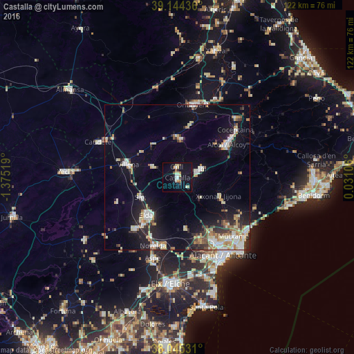
Analysis of Castalla night lights 2016
Square area 10x10 km:
100  2.44%
2.44%
90-99 1.79%
80-89 3.57%
70-79 1.46%
60-69 2.76%
50-59 0.81%
40-49 0.81%
30-39 1.46%
20-29 0.81%
10-19 16.4%
0-9 67.69%
2.44%90-99
1.79%80-89
3.57%70-79
1.46%60-69
2.76%50-59
0.81%40-49
0.81%30-39
1.46%20-29
0.81%10-19
16.4%0-9
67.69%Square area 50x50 km:
100 1.95%
90-99 2.71%
80-89 1.98%
70-79 1.48%
60-69 1.7%
50-59 1.3%
40-49 1.15%
30-39 1.74%
20-29 3.17%
10-19 9.8%
0-9 73.04%
1.95%90-99
2.71%80-89
1.98%70-79
1.48%60-69
1.7%50-59
1.3%40-49
1.15%30-39
1.74%20-29
3.17%10-19
9.8%0-9
73.04%Clear (daylight) street map image can be seen on geolist.org.
Map coordinates:
39° 8' 39.7" North, 1° 22' 30.7" West
38° 35' 49" North, 0° 40' 19.5" West
38° 2' 43.1" North, 0° 1' 51.8" East
Some cities around Castalla sort by population:
• Alcoy
21 km =13 mi,  54°
54°
• Elda
16.8 km =10.4 mi,  218°
218°
• Villena
17.4 km =10.8 mi,  284°
284°
• Ibi
9.2 km =5.7 mi,  69°
69°
• Monóvar
23 km =14.3 mi, 219°
• Sax
14.3 km =8.9 mi,  242°
242°
• Onil
3.2 km =2 mi,  358°
358°
• Jijona
16 km =9.9 mi,  112°
112°
2519783 (p: 10,327)
Sources (retrieved 2019-11-25):
» Earth at Night: Flat Maps 2012, 2016