Ibi night lights from space
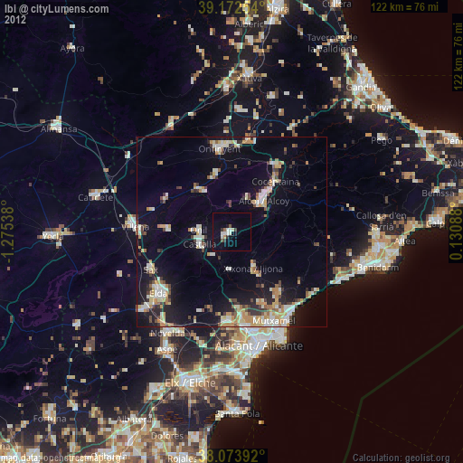
Night Light of Ibi (Valencia) from space (Spain) Src. Average luminocity for 10x10km area is 13.5552% and for 50x50km: 12.4697%.
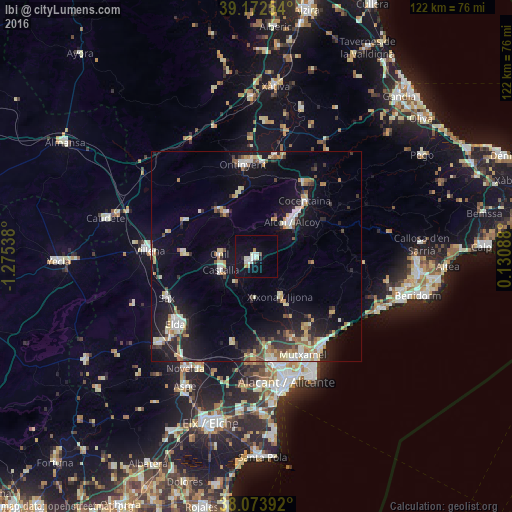
Analysis of Ibi night lights 2016
Square area 10x10 km:
100  3.41%
3.41%
90-99 2.92%
80-89 0.81%
70-79 0.65%
60-69 1.3%
50-59 0%
40-49 0.65%
30-39 0.32%
20-29 0.97%
10-19 8.12%
0-9 80.84%
3.41%90-99
2.92%80-89
0.81%70-79
0.65%60-69
1.3%50-59
0%40-49
0.65%30-39
0.32%20-29
0.97%10-19
8.12%0-9
80.84%Square area 50x50 km:
100 1.53%
90-99 2.08%
80-89 1.84%
70-79 1.34%
60-69 1.32%
50-59 1.18%
40-49 1.06%
30-39 1.57%
20-29 3.07%
10-19 9.82%
0-9 75.19%
1.53%90-99
2.08%80-89
1.84%70-79
1.34%60-69
1.32%50-59
1.18%40-49
1.06%30-39
1.57%20-29
3.07%10-19
9.82%0-9
75.19%Clear (daylight) street map image can be seen on geolist.org.
Map coordinates:
39° 10' 21.1" North, 1° 16' 31.4" West
38° 37' 31.2" North, 0° 34' 20.1" West
38° 4' 26.1" North, 0° 7' 51.2" East
Some cities around Ibi sort by population:
• Alcoy
12.3 km =7.6 mi,  43°
43°
• Ontinyent
22.1 km =13.7 mi,  352°
352°
• Cocentaina
17.1 km =10.6 mi, 42°
• Castalla
9.2 km =5.7 mi,  249°
249°
• Sax
23.5 km =14.6 mi, 245°
• Muro del Alcoy
21 km =13 mi,  34°
34°
• Onil
8.8 km =5.5 mi,  270°
270°
• Jijona
11.2 km =7 mi,  147°
147°
2516480 (p: 24,113)
Sources (retrieved 2019-11-25):
» Earth at Night: Flat Maps 2012, 2016