Membrilla night lights from space
Night Light of Membrilla (Castille-La Mancha) from space (Spain) Src. Average luminocity for 10x10km area is 16.6867% and for 50x50km: 3.7072%.
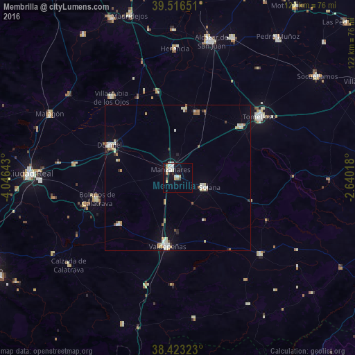
Analysis of Membrilla night lights 2016
Square area 10x10 km:
 3.9%
3.9%90-99
4.71%80-89
0.32%70-79
3.08%60-69
1.3%50-59
0%40-49
0.32%30-39
1.79%20-29
0.49%10-19
11.85%0-9
72.24%Square area 50x50 km:
0.5%90-99
0.89%80-89
0.5%70-79
0.46%60-69
0.42%50-59
0.24%40-49
0.18%30-39
0.29%20-29
0.21%10-19
1.42%0-9
94.91%Clear (daylight) street map image can be seen on geolist.org.
Map coordinates:
39° 30' 59.4" North, 4° 2' 47.1" West
38° 58' 19.1" North, 3° 20' 35.9" West
38° 25' 23.6" North, 2° 38' 24.6" West
Some cities around Membrilla sort by population:
• Valdepeñas
23.6 km =14.7 mi,  188°
188°
• Manzanares
3.8 km =2.4 mi,  322°
322°
• Daimiel
25.9 km =16.1 mi,  294°
294°
• La Solana
9.6 km =6 mi,  108°
108°
• Bolaños de Calatrava
28.6 km =17.8 mi,  255°
255°
• Almagro
33.1 km =20.6 mi,  253°
253°
• Argamasilla de Alba
27.8 km =17.3 mi,  51°
51°
• Moral de Calatrava
25.7 km =16 mi,  232°
232°
2513944 (p: 6,466)
Sources (retrieved 2019-11-25):
» Earth at Night: Flat Maps 2012, 2016