Daimiel night lights from space
Night Light of Daimiel (Castille-La Mancha) from space (Spain) Src. Average luminocity for 10x10km area is 14.8539% and for 50x50km: 3.7301%.
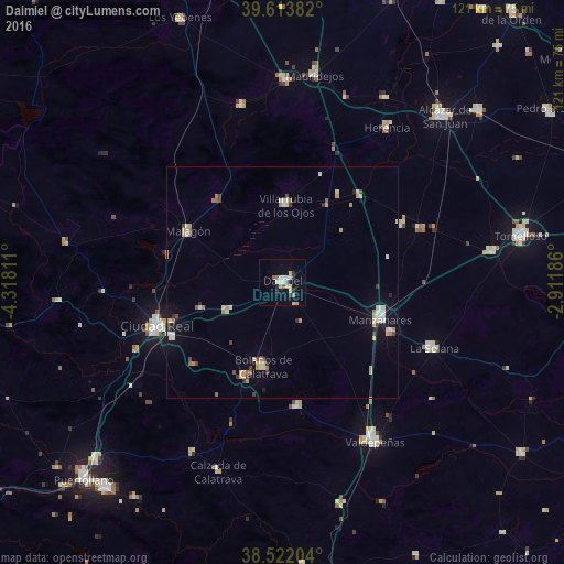
Analysis of Daimiel night lights 2016
Square area 10x10 km:
 1.79%
1.79%90-99
3.57%80-89
2.6%70-79
1.14%60-69
1.79%50-59
1.46%40-49
0%30-39
2.44%20-29
0.81%10-19
4.71%0-9
79.71%Square area 50x50 km:
0.37%90-99
0.67%80-89
0.51%70-79
0.65%60-69
0.54%50-59
0.21%40-49
0.31%30-39
0.5%20-29
0.24%10-19
1.3%0-9
94.7%Clear (daylight) street map image can be seen on geolist.org.
Map coordinates:
39° 36' 49.8" North, 4° 19' 5.2" West
39° 4' 12.1" North, 3° 36' 53.9" West
38° 31' 19.3" North, 2° 54' 42.7" West
Some cities around Daimiel sort by population:
• Manzanares
22.6 km =14 mi,  110°
110°
• Miguelturra
26.5 km =16.5 mi,  243°
243°
• Bolaños de Calatrava
18.6 km =11.6 mi,  193°
193°
• Villarrubia de los Ojos
16.8 km =10.4 mi,  2°
2°
• Almagro
21.7 km =13.5 mi,  202°
202°
• Malagón
23.3 km =14.5 mi,  297°
297°
• Membrilla
25.9 km =16.1 mi, 114°
• Moral de Calatrava
26.9 km =16.7 mi,  173°
173°
2518924 (p: 18,527)
Sources (retrieved 2019-11-25):
» Earth at Night: Flat Maps 2012, 2016