Matadepera night lights from space
Night Light of Matadepera (Catalonia) from space (Spain) Src. Average luminocity for 10x10km area is 58.6591% and for 50x50km: 43.3005%.
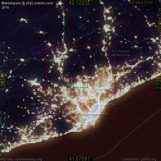
Analysis of Matadepera night lights 2016
Square area 10x10 km:
 12.34%
90-99
13.64%80-89
6.17%70-79
8.12%60-69
11.2%50-59
9.25%40-49
6.01%30-39
5.52%20-29
11.69%10-19
13.96%0-9
2.11%Square area 50x50 km:
9.33%90-99
9.4%80-89
4.76%70-79
5.63%60-69
7.91%50-59
6%40-49
4.3%30-39
4.11%20-29
9.23%10-19
13.48%0-9
25.87%Clear (daylight) street map image can be seen on geolist.org.
Map coordinates:
42° 7' 21.1" North, 1° 19' 24.1" East
41° 35' 55.9" North, 2° 1' 35.3" East
41° 4' 15.3" North, 2° 43' 46.6" East
Some cities around Matadepera sort by population:
• Terrassa
3.7 km =2.3 mi,  192°
192°
• Sabadell
9.3 km =5.8 mi,  131°
131°
• Rubí
11.9 km =7.4 mi,  177°
177°
• Castellar del Vallès
5.1 km =3.2 mi,  67°
67°
• Sant Quirze del Vallès
8.7 km =5.4 mi,  147°
147°
• Caldes de Montbui
12.3 km =7.6 mi, 71°
• Sentmenat
9.1 km =5.7 mi,  83°
83°
• Polinyà
11.6 km =7.2 mi,  117°
117°
3117200 (p: 7,970)
Sources (retrieved 2019-11-25):
» Earth at Night: Flat Maps 2012, 2016