Caldes de Montbui night lights from space
Night Light of Caldes de Montbui (Catalonia) from space (Spain) Src. Average luminocity for 10x10km area is 50.8588% and for 50x50km: 38.6469%.
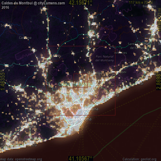
Analysis of Caldes de Montbui night lights 2016
Square area 10x10 km:
 3.08%
3.08%90-99
6.82%80-89
6.01%70-79
8.12%60-69
16.4%50-59
12.99%40-49
11.2%30-39
7.47%20-29
11.36%10-19
13.31%0-9
3.25%Square area 50x50 km:
8.01%90-99
8.55%80-89
4.26%70-79
5%60-69
7.32%50-59
5.59%40-49
3.83%30-39
4.08%20-29
7.72%10-19
10.42%0-9
35.21%Clear (daylight) street map image can be seen on geolist.org.
Map coordinates:
42° 9' 24.2" North, 1° 27' 48.8" East
41° 37' 60" North, 2° 10' 0" East
41° 6' 20.4" North, 2° 52' 11.3" East
Some cities around Caldes de Montbui sort by population:
• Castellar del Vallès
7.2 km =4.5 mi,  255°
255°
• Parets del Vallès
8.5 km =5.3 mi,  139°
139°
• Lliçà d'Amunt
5.8 km =3.6 mi,  108°
108°
• Sentmenat
3.8 km =2.4 mi,  223°
223°
• L'Ametlla del Vallès
9.1 km =5.7 mi,  65°
65°
• Bigues i Riells
7.8 km =4.8 mi,  44°
44°
• Polinyà
9.4 km =5.8 mi,  188°
188°
• Santa Eulàlia de Ronçana
5.8 km =3.6 mi, 71°
3127035 (p: 16,885)
Sources (retrieved 2019-11-25):
» Earth at Night: Flat Maps 2012, 2016