Sentmenat night lights from space
Night Light of Sentmenat (Catalonia) from space (Spain) Src. Average luminocity for 10x10km area is 58.5146% and for 50x50km: 42.0355%.
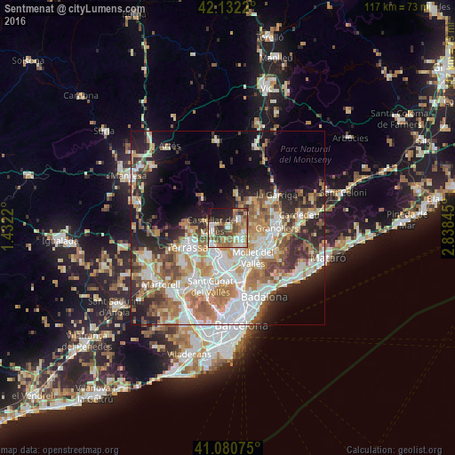
Analysis of Sentmenat night lights 2016
Square area 10x10 km:
 8.6%
8.6%90-99
12.66%80-89
7.63%70-79
5.52%60-69
13.64%50-59
12.18%40-49
10.23%30-39
7.63%20-29
10.88%10-19
11.04%0-9
0%Square area 50x50 km:
9.18%90-99
9.21%80-89
4.66%70-79
5.54%60-69
7.84%50-59
5.77%40-49
4.26%30-39
4.48%20-29
8.47%10-19
10.42%0-9
30.19%Clear (daylight) street map image can be seen on geolist.org.
Map coordinates:
42° 7' 55.9" North, 1° 25' 55.9" East
41° 36' 31" North, 2° 8' 7.2" East
41° 4' 50.7" North, 2° 50' 18.4" East
Some cities around Sentmenat sort by population:
• Sabadell
7.6 km =4.7 mi,  196°
196°
• Santa Perpètua de Mogoda
9.3 km =5.8 mi,  154°
154°
• Castellar del Vallès
4.4 km =2.7 mi,  281°
281°
• Parets del Vallès
9 km =5.6 mi,  114°
114°
• Caldes de Montbui
3.8 km =2.4 mi,  43°
43°
• Lliçà d'Amunt
8.2 km =5.1 mi,  83°
83°
• Matadepera
9.1 km =5.7 mi,  263°
263°
• Polinyà
6.6 km =4.1 mi,  169°
169°
3109165 (p: 7,633)
Sources (retrieved 2019-11-25):
» Earth at Night: Flat Maps 2012, 2016