Polinyà night lights from space
Night Light of Polinyà (Catalonia) from space (Spain) Src. Average luminocity for 10x10km area is 86.3639% and for 50x50km: 45.4901%.
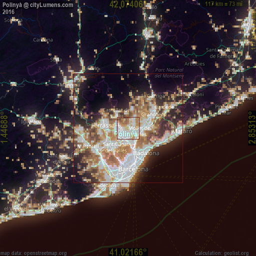
Analysis of Polinyà night lights 2016
Square area 10x10 km:
 30.78%
90-99
27.72%80-89
8.16%70-79
13.44%60-69
11.22%50-59
5.1%40-49
3.23%30-39
0.34%20-29
0%10-19
0%0-9
0%Square area 50x50 km:
11.04%90-99
10.22%80-89
4.6%70-79
5.71%60-69
8.2%50-59
6.43%40-49
4.4%30-39
4.73%20-29
8.31%10-19
9.72%0-9
26.64%Clear (daylight) street map image can be seen on geolist.org.
Map coordinates:
42° 4' 26.6" North, 1° 26' 48.8" East
41° 33' 0" North, 2° 9' 0" East
41° 1' 18" North, 2° 51' 11.3" East
Some cities around Polinyà sort by population:
• Sabadell
3.5 km =2.2 mi,  257°
257°
• Cerdanyola del Vallès
6.6 km =4.1 mi,  186°
186°
• Mollet del Vallès
5.4 km =3.4 mi,  101°
101°
• Ripollet
5.9 km =3.7 mi,  174°
174°
• Barberà del Vallès
4.3 km =2.7 mi,  209°
209°
• Santa Perpètua de Mogoda
3.3 km =2.1 mi,  123°
123°
• Sant Quirze del Vallès
5.8 km =3.6 mi,  251°
251°
• La Llagosta
5.3 km =3.3 mi,  137°
137°
3113254 (p: 6,176)
Sources (retrieved 2019-11-25):
» Earth at Night: Flat Maps 2012, 2016