Las Tres Torres night lights from space
Night Light of Las Tres Torres (Catalonia) from space (Spain) Src. Average luminocity for 10x10km area is 92.5782% and for 50x50km: 43.5281%.
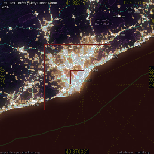
Analysis of Las Tres Torres night lights 2016
Square area 10x10 km:
 52.55%
90-99
25.34%80-89
1.7%70-79
6.97%60-69
12.07%50-59
1.36%40-49
0%30-39
0%20-29
0%10-19
0%0-9
0%Square area 50x50 km:
11.51%90-99
10.3%80-89
4.24%70-79
5.28%60-69
7.72%50-59
5.76%40-49
3.63%30-39
4.06%20-29
7.66%10-19
7.48%0-9
32.36%Clear (daylight) street map image can be seen on geolist.org.
Map coordinates:
41° 55' 30.6" North, 1° 25' 34.2" East
41° 23' 59.6" North, 2° 7' 45.5" East
40° 52' 13.2" North, 2° 49' 56.7" East
Some cities around Las Tres Torres sort by population:
• Sarrià-Sant Gervasi
0.9 km =0.6 mi,  81°
81°
• Les Corts
1.4 km =0.9 mi,  177°
177°
• Sant Gervasi - Galvany
1.2 km =0.7 mi,  103°
103°
• Barri de les Corts
1.5 km =0.9 mi,  162°
162°
• el Putxet i el Farró
1.4 km =0.9 mi,  57°
57°
• La Bonanova
0.7 km =0.4 mi,  21°
21°
• Sarrià
1.1 km =0.7 mi,  285°
285°
• Vallcarca
1.8 km =1.1 mi,  41°
41°
6545108 (p: 16,532)
Sources (retrieved 2019-11-25):
» Earth at Night: Flat Maps 2012, 2016