La Rambla night lights from space
Night Light of La Rambla (Andalusia) from space (Spain) Src. Average luminocity for 10x10km area is 12.0765% and for 50x50km: 6.1322%.
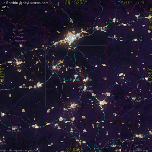
Analysis of La Rambla night lights 2016
Square area 10x10 km:
 0.51%
0.51%90-99
1.53%80-89
1.36%70-79
2.72%60-69
1.02%50-59
1.36%40-49
0.68%30-39
2.55%20-29
2.55%10-19
0%0-9
85.71%Square area 50x50 km:
0.45%90-99
0.66%80-89
1.12%70-79
0.82%60-69
1.01%50-59
0.34%40-49
0.56%30-39
1%20-29
0.78%10-19
3.9%0-9
89.35%Clear (daylight) street map image can be seen on geolist.org.
Map coordinates:
38° 9' 45.1" North, 5° 26' 33.9" West
37° 36' 27.4" North, 4° 44' 22.6" West
37° 2' 54.6" North, 4° 2' 11.4" West
Some cities around La Rambla sort by population:
• Puente-Genil
24.4 km =15.2 mi,  185°
185°
• Montilla
9.3 km =5.8 mi,  104°
104°
• Aguilar
12.6 km =7.8 mi,  144°
144°
• La Carlota
18.4 km =11.4 mi,  293°
293°
• Fernán-Núñez
7.1 km =4.4 mi,  9°
9°
• Castro del Río
24.6 km =15.3 mi,  67°
67°
• Santaella
10.4 km =6.5 mi,  241°
241°
• Nueva-Carteya
24.1 km =15 mi, 95°
2515597 (p: 7,374)
Sources (retrieved 2019-11-25):
» Earth at Night: Flat Maps 2012, 2016