La Carlota night lights from space
Night Light of La Carlota (Andalusia) from space (Spain) Src. Average luminocity for 10x10km area is 20.2194% and for 50x50km: 7.9341%.
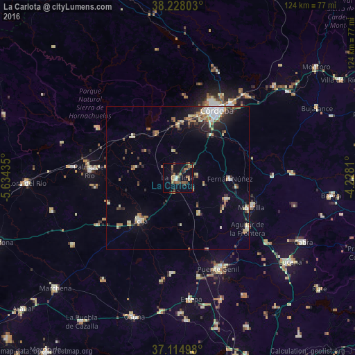
Analysis of La Carlota night lights 2016
Square area 10x10 km:
 1.19%
1.19%90-99
0.51%80-89
2.04%70-79
3.74%60-69
5.78%50-59
2.72%40-49
3.74%30-39
4.76%20-29
1.7%10-19
16.84%0-9
56.97%Square area 50x50 km:
1.04%90-99
0.89%80-89
1.03%70-79
0.98%60-69
1.48%50-59
0.74%40-49
0.81%30-39
1.2%20-29
1.89%10-19
3.49%0-9
86.44%Clear (daylight) street map image can be seen on geolist.org.
Map coordinates:
38° 13' 40.9" North, 5° 38' 3.7" West
37° 40' 24.9" North, 4° 55' 52.4" West
37° 6' 53.9" North, 4° 13' 41.2" West
Some cities around La Carlota sort by population:
• Écija
19.8 km =12.3 mi,  222°
222°
• Montilla
27.6 km =17.1 mi,  110°
110°
• Fuente Palmera
15.2 km =9.4 mi,  283°
283°
• Fernán-Núñez
18 km =11.2 mi,  91°
91°
• Almodóvar del Río
17.1 km =10.6 mi,  332°
332°
• La Rambla
18.4 km =11.4 mi, 113°
• Posadas
21.1 km =13.1 mi,  312°
312°
• Santaella
14.5 km =9 mi,  147°
147°
2516089 (p: 13,182)
Sources (retrieved 2019-11-25):
» Earth at Night: Flat Maps 2012, 2016