la Font de la Guatlla night lights from space
Night Light of la Font de la Guatlla (Catalonia) from space (Spain) Src. Average luminocity for 10x10km area is 91.6224% and for 50x50km: 39.8136%.
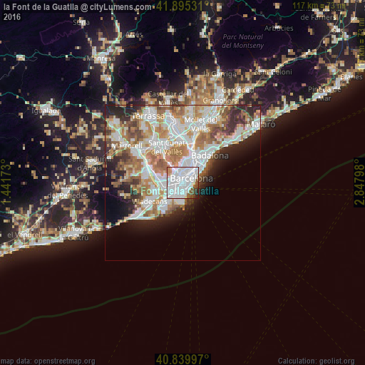
Analysis of la Font de la Guatlla night lights 2016
Square area 10x10 km:
 56.97%
90-99
26.02%80-89
1.02%70-79
2.38%60-69
1.53%50-59
5.61%40-49
3.57%30-39
1.19%20-29
1.53%10-19
0.17%0-9
0%Square area 50x50 km:
11.23%90-99
9.77%80-89
3.62%70-79
4.78%60-69
6.78%50-59
5.07%40-49
3.02%30-39
3.45%20-29
6.23%10-19
6.04%0-9
40%Clear (daylight) street map image can be seen on geolist.org.
Map coordinates:
41° 53' 43.1" North, 1° 26' 30.2" East
41° 22' 11.2" North, 2° 8' 41.5" East
40° 50' 23.9" North, 2° 50' 52.7" East
Some cities around la Font de la Guatlla sort by population:
• Sants-Montjuïc
0.9 km =0.6 mi,  68°
68°
• la Nova Esquerra de l'Eixample
1.5 km =0.9 mi,  13°
13°
• Sants
0.7 km =0.4 mi,  312°
312°
• Sant Antoni
1.6 km =1 mi,  51°
51°
• la Marina de Port
1.2 km =0.7 mi,  200°
200°
• Sants - Badal
1.5 km =0.9 mi,  291°
291°
• La Bordeta
0.5 km =0.3 mi,  348°
348°
• Hostafrancs
0.8 km =0.5 mi, 349°
11549786 (p: 10,481)
Sources (retrieved 2019-11-25):
» Earth at Night: Flat Maps 2012, 2016