Hostafrancs night lights from space
Night Light of Hostafrancs (Catalonia) from space (Spain) Src. Average luminocity for 10x10km area is 93.0323% and for 50x50km: 40.8401%.
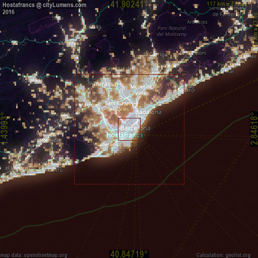
Analysis of Hostafrancs night lights 2016
Square area 10x10 km:
 59.35%
90-99
25%80-89
1.02%70-79
3.74%60-69
2.21%50-59
4.42%40-49
2.55%30-39
0.68%20-29
1.02%10-19
0%0-9
0%Square area 50x50 km:
11.36%90-99
9.94%80-89
3.77%70-79
4.93%60-69
7%50-59
5.34%40-49
3.19%30-39
3.59%20-29
6.53%10-19
6.23%0-9
38.13%Clear (daylight) street map image can be seen on geolist.org.
Map coordinates:
41° 54' 8.7" North, 1° 26' 23.7" East
41° 22' 37" North, 2° 8' 35" East
40° 50' 49.9" North, 2° 50' 46.2" East
Some cities around Hostafrancs sort by population:
• Sants-Montjuïc
1.1 km =0.7 mi,  116°
116°
• la Nova Esquerra de l'Eixample
0.8 km =0.5 mi,  35°
35°
• Barri de les Corts
1.3 km =0.8 mi,  328°
328°
• Sants
0.5 km =0.3 mi,  233°
233°
• Sant Antoni
1.4 km =0.9 mi,  82°
82°
• Sants - Badal
1.3 km =0.8 mi,  259°
259°
• La Bordeta
0.3 km =0.2 mi,  169°
169°
• la Font de la Guatlla
0.8 km =0.5 mi, 169°
6545104 (p: 15,954)
Sources (retrieved 2019-11-25):
» Earth at Night: Flat Maps 2012, 2016