Posadas night lights from space
Night Light of Posadas (Andalusia) from space (Spain) Src. Average luminocity for 10x10km area is 5.6956% and for 50x50km: 5.2207%.
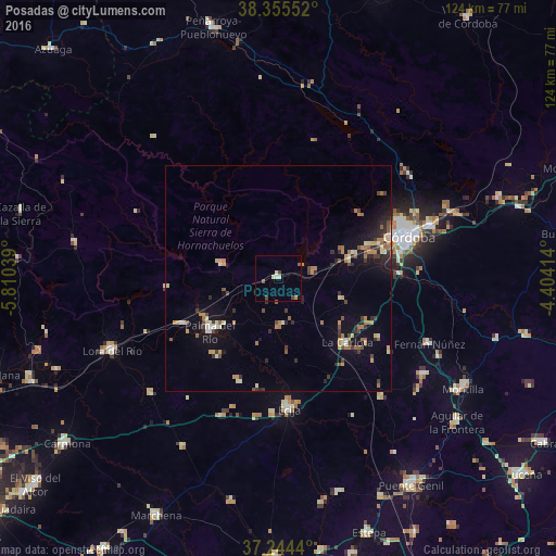
Analysis of Posadas night lights 2016
Square area 10x10 km:
 0.17%
0.17%90-99
0.85%80-89
1.7%70-79
0.51%60-69
0.17%50-59
0.68%40-49
2.04%30-39
0.68%20-29
0%10-19
0.17%0-9
93.03%Square area 50x50 km:
0.24%90-99
0.49%80-89
0.7%70-79
0.71%60-69
1.01%50-59
0.59%40-49
0.82%30-39
0.88%20-29
1.19%10-19
3.32%0-9
90.06%Clear (daylight) street map image can be seen on geolist.org.
Map coordinates:
38° 21' 19.9" North, 5° 48' 37.4" West
37° 48' 7.4" North, 5° 6' 26.1" West
37° 14' 39.8" North, 4° 24' 14.9" West
Some cities around Posadas sort by population:
• Córdoba
31 km =19.3 mi,  71°
71°
• Écija
29 km =18 mi,  175°
175°
• Palma del Río
19 km =11.8 mi,  233°
233°
• La Carlota
21.1 km =13.1 mi,  132°
132°
• Fuente Palmera
10.8 km =6.7 mi, 176°
• Fernán-Núñez
36.5 km =22.7 mi,  113°
113°
• Almodóvar del Río
7.7 km =4.8 mi,  82°
82°
• Santaella
35.3 km =21.9 mi,  138°
138°
2512367 (p: 7,364)
Sources (retrieved 2019-11-25):
» Earth at Night: Flat Maps 2012, 2016