L'Olleria night lights from space
Night Light of L'Olleria (Valencia) from space (Spain) Src. Average luminocity for 10x10km area is 16.7313% and for 50x50km: 9.7591%.
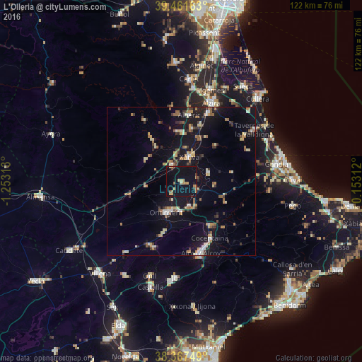
Analysis of L'Olleria night lights 2016
Square area 10x10 km:
 0%
0%90-99
0.68%80-89
4.93%70-79
2.38%60-69
1.87%50-59
1.19%40-49
1.02%30-39
1.02%20-29
0.51%10-19
26.36%0-9
60.03%Square area 50x50 km:
0.66%90-99
1.08%80-89
1.42%70-79
1.39%60-69
1.3%50-59
1.22%40-49
0.75%30-39
1.56%20-29
1.42%10-19
10.34%0-9
78.87%Clear (daylight) street map image can be seen on geolist.org.
Map coordinates:
39° 27' 41.9" North, 1° 15' 11.3" West
38° 55' 0" North, 0° 33' 0" West
38° 22' 3" North, 0° 9' 11.2" East
Some cities around L'Olleria sort by population:
• Ontinyent
11.6 km =7.2 mi,  204°
204°
• Xàtiva
8.6 km =5.3 mi,  18°
18°
• Canals
5.9 km =3.7 mi,  329°
329°
• Muro del Alcoy
18 km =11.2 mi,  146°
146°
• Villanueva de Castellón
18.2 km =11.3 mi,  10°
10°
• Albaida
9.2 km =5.7 mi,  162°
162°
• Benigànim
10.7 km =6.6 mi,  69°
69°
• Enguera
13.8 km =8.6 mi,  300°
300°
2513130 (p: 7,648)
Sources (retrieved 2019-11-25):
» Earth at Night: Flat Maps 2012, 2016