San Lorenzo de El Escorial night lights from space
Night Light of San Lorenzo de El Escorial (Madrid) from space (Spain) Src. Average luminocity for 10x10km area is 22.7614% and for 50x50km: 19.1882%.
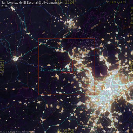
Analysis of San Lorenzo de El Escorial night lights 2016
Square area 10x10 km:
 2.92%
2.92%90-99
3.9%80-89
2.44%70-79
4.22%60-69
0.81%50-59
0.65%40-49
2.11%30-39
2.76%20-29
2.27%10-19
42.21%0-9
35.71%Square area 50x50 km:
2.08%90-99
3.64%80-89
1.87%70-79
2.84%60-69
3.23%50-59
2.55%40-49
2.48%30-39
3.29%20-29
6.05%10-19
10.81%0-9
61.16%Clear (daylight) street map image can be seen on geolist.org.
Map coordinates:
41° 7' 23.7" North, 4° 51' 1.8" West
40° 35' 29.2" North, 4° 8' 50.6" West
40° 3' 19.4" North, 3° 26' 39.3" West
Some cities around San Lorenzo de El Escorial sort by population:
• Collado-Villalba
13 km =8.1 mi,  68°
68°
• Galapagar
12.2 km =7.6 mi,  96°
96°
• El Escorial
1.9 km =1.2 mi,  121°
121°
• Guadarrama
10.3 km =6.4 mi,  28°
28°
• Alpedrete
12.8 km =8 mi,  53°
53°
• Valdemorillo
12.2 km =7.6 mi,  146°
146°
• Colmenarejo
11.5 km =7.1 mi,  107°
107°
• Collado Mediano
15.4 km =9.6 mi,  42°
42°
3110458 (p: 17,889)
Sources (retrieved 2019-11-25):
» Earth at Night: Flat Maps 2012, 2016