el Parc i la Llacuna del Poblenou night lights from space
Night Light of el Parc i la Llacuna del Poblenou (Catalonia) from space (Spain) Src. Average luminocity for 10x10km area is 82.3384% and for 50x50km: 41.7277%.
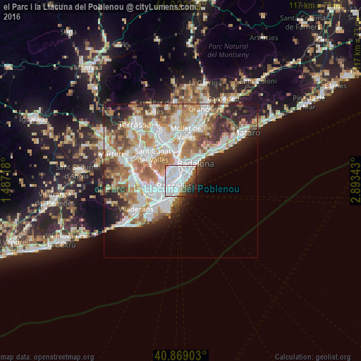
Analysis of el Parc i la Llacuna del Poblenou night lights 2016
Square area 10x10 km:
 50.68%
90-99
20.58%80-89
0.68%70-79
0.68%60-69
0.34%50-59
9.01%40-49
4.76%30-39
4.25%20-29
4.93%10-19
3.91%0-9
0.17%Square area 50x50 km:
11.38%90-99
10.22%80-89
3.97%70-79
4.97%60-69
7.46%50-59
5.34%40-49
3.34%30-39
3.76%20-29
6.8%10-19
6.35%0-9
36.42%Clear (daylight) street map image can be seen on geolist.org.
Map coordinates:
41° 55' 26" North, 1° 29' 13.8" East
41° 23' 55" North, 2° 11' 25.1" East
40° 52' 8.5" North, 2° 53' 36.3" East
Some cities around el Parc i la Llacuna del Poblenou sort by population:
• Sagrada Família
1.5 km =0.9 mi,  293°
293°
• el Camp de l'Arpa del Clot
1.6 km =1 mi,  336°
336°
• el Poblenou
1.3 km =0.8 mi,  62°
62°
• Fort Pienc
1 km =0.6 mi,  243°
243°
• el Clot
1.3 km =0.8 mi,  0°
0°
• Sant Pere, Santa Caterina i La Ribera
1.7 km =1.1 mi,  205°
205°
• Provenals del Poblenou
1.7 km =1.1 mi,  36°
36°
• la Vila Olímpica del Poblenou
1 km =0.6 mi,  148°
148°
11549775 (p: 14,950)
Sources (retrieved 2019-11-25):
» Earth at Night: Flat Maps 2012, 2016