Colindres night lights from space
Night Light of Colindres (Cantabria) from space (Spain) Src. Average luminocity for 10x10km area is 26.8952% and for 50x50km: 6.8555%.
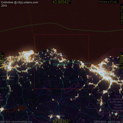
Analysis of Colindres night lights 2016
Square area 10x10 km:
 1.43%
1.43%90-99
1.43%80-89
3.02%70-79
5.56%60-69
5.4%50-59
4.29%40-49
2.06%30-39
4.13%20-29
6.19%10-19
45.71%0-9
20.79%Square area 50x50 km:
0.32%90-99
0.39%80-89
0.57%70-79
0.75%60-69
1.16%50-59
1.53%40-49
1.24%30-39
1.54%20-29
1.91%10-19
7.52%0-9
83.08%Clear (daylight) street map image can be seen on geolist.org.
Map coordinates:
43° 54' 19.5" North, 4° 9' 24.3" West
43° 23' 48" North, 3° 27' 13" West
42° 53' 1" North, 2° 45' 1.8" West
Some cities around Colindres sort by population:
• Santander
29.3 km =18.2 mi,  284°
284°
• Castro-Urdiales
18.9 km =11.7 mi,  94°
94°
• El Astillero
29.6 km =18.4 mi,  270°
270°
• Laredo
3.4 km =2.1 mi,  64°
64°
• Santoña
5.3 km =3.3 mi,  356°
356°
• Zierbena
30.4 km =18.9 mi,  99°
99°
• Zalla
31.6 km =19.6 mi,  125°
125°
• Santa María de Cayón
32.5 km =20.2 mi,  252°
252°
3124821 (p: 7,179)
Sources (retrieved 2019-11-25):
» Earth at Night: Flat Maps 2012, 2016