El Astillero night lights from space
Night Light of El Astillero (Cantabria) from space (Spain) Src. Average luminocity for 10x10km area is 54.2778% and for 50x50km: 15.0421%.
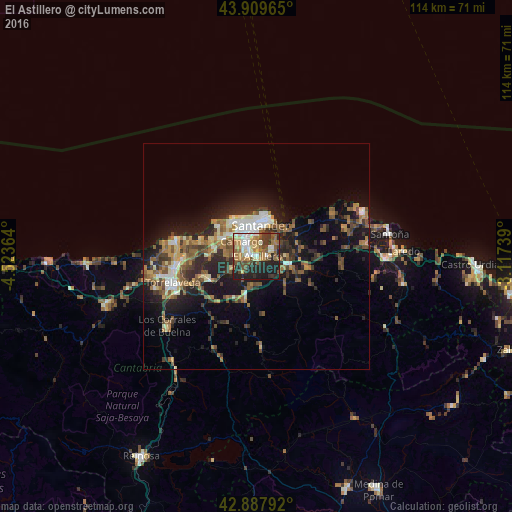
Analysis of El Astillero night lights 2016
Square area 10x10 km:
 7.3%
7.3%90-99
9.05%80-89
7.78%70-79
7.14%60-69
13.65%50-59
10%40-49
6.98%30-39
7.78%20-29
19.52%10-19
10.79%0-9
0%Square area 50x50 km:
1.47%90-99
2%80-89
1.56%70-79
1.47%60-69
2.94%50-59
3.61%40-49
2.06%30-39
2.74%20-29
5.37%10-19
9.46%0-9
67.33%Clear (daylight) street map image can be seen on geolist.org.
Map coordinates:
43° 54' 34.7" North, 4° 31' 25.1" West
43° 24' 3.4" North, 3° 49' 13.8" West
42° 53' 16.5" North, 3° 7' 2.6" West
Some cities around El Astillero sort by population:
• Santander
7.2 km =4.5 mi,  10°
10°
• Torrelavega
19.2 km =11.9 mi,  252°
252°
• Camargo
5.3 km =3.3 mi,  277°
277°
• Los Corrales de Buelna
25.5 km =15.8 mi,  233°
233°
• Santa Cruz de Bezana
8.2 km =5.1 mi,  305°
305°
• Reocín
23.2 km =14.4 mi, 252°
• Suances
18.4 km =11.4 mi, 281°
• Santa María de Cayón
10.4 km =6.5 mi,  187°
187°
3123667 (p: 17,360)
Sources (retrieved 2019-11-25):
» Earth at Night: Flat Maps 2012, 2016