Zierbena night lights from space
Night Light of Zierbena (Basque Country) from space (Spain) Src. Average luminocity for 10x10km area is 56.4% and for 50x50km: 17.2104%.
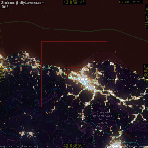
Analysis of Zierbena night lights 2016
Square area 10x10 km:
100  13.97%
90-99 13.65%
80-89 4.29%
70-79 8.57%
60-69 6.83%
50-59 7.62%
40-49 5.56%
30-39 4.92%
20-29 14.13%
10-19 18.73%
0-9 1.75%
13.97%90-99
13.65%80-89
4.29%70-79
8.57%60-69
6.83%50-59
7.62%40-49
5.56%30-39
4.92%20-29
14.13%10-19
18.73%0-9
1.75%Square area 50x50 km:
100 2.94%
90-99 3.33%
80-89 1.58%
70-79 1.76%
60-69 2.06%
50-59 2.67%
40-49 2.05%
30-39 2.65%
20-29 5.25%
10-19 11.18%
0-9 64.53%
2.94%90-99
3.33%80-89
1.58%70-79
1.76%60-69
2.06%50-59
2.67%40-49
2.05%30-39
2.65%20-29
5.25%10-19
11.18%0-9
64.53%Clear (daylight) street map image can be seen on geolist.org.
Map coordinates:
43° 51' 32.9" North, 3° 47' 11.2" West
43° 21' 0" North, 3° 4' 60" West
42° 50' 11.6" North, 2° 22' 48.7" West
Some cities around Zierbena sort by population:
• Algorta
6 km =3.7 mi,  90°
90°
• Getxo
5.9 km =3.7 mi,  82°
82°
• Portugalete
6 km =3.7 mi,  122°
122°
• Santurtzi
4.8 km =3 mi, 120°
• Leioa
8.1 km =5 mi,  108°
108°
• Sestao
7.6 km =4.7 mi,  125°
125°
• Ortuella
4.8 km =3 mi,  153°
153°
• Berango
7.3 km =4.5 mi, 76°
3125077 (p: 9,418)
Sources (retrieved 2019-11-25):
» Earth at Night: Flat Maps 2012, 2016