Campanario night lights from space
Night Light of Campanario (Extremadura) from space (Spain) Src. Average luminocity for 10x10km area is 4.7857% and for 50x50km: 2.7393%.
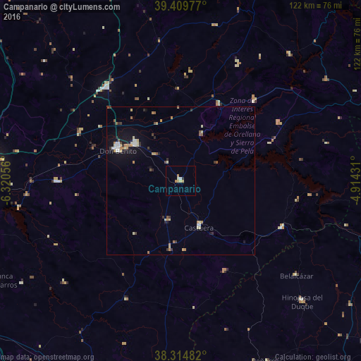
Analysis of Campanario night lights 2016
Square area 10x10 km:
 0%
0%90-99
0.68%80-89
1.19%70-79
2.55%60-69
0.34%50-59
0%40-49
0%30-39
0%20-29
0.68%10-19
0%0-9
94.56%Square area 50x50 km:
0.28%90-99
0.35%80-89
0.49%70-79
0.48%60-69
0.35%50-59
0.25%40-49
0.2%30-39
0.32%20-29
0.3%10-19
1.78%0-9
95.21%Clear (daylight) street map image can be seen on geolist.org.
Map coordinates:
39° 24' 35.2" North, 6° 19' 14" West
38° 51' 51.8" North, 5° 37' 2.8" West
38° 18' 53.4" North, 4° 54' 51.5" West
Some cities around Campanario sort by population:
• Don Benito
23.5 km =14.6 mi,  295°
295°
• Villanueva de la Serena
19.9 km =12.4 mi,  308°
308°
• Miajadas
40.6 km =25.2 mi,  321°
321°
• El Casar
45.7 km =28.4 mi,  215°
215°
• Guareña
41.8 km =26 mi,  269°
269°
• Castuera
16 km =9.9 mi,  156°
156°
• Cabeza del Buey
37.9 km =23.5 mi,  114°
114°
• Quintana de la Serena
14 km =8.7 mi,  199°
199°
2520456 (p: 5,522)
Sources (retrieved 2019-11-25):
» Earth at Night: Flat Maps 2012, 2016