Guareña night lights from space
Night Light of Guareña (Extremadura) from space (Spain) Src. Average luminocity for 10x10km area is 5.318% and for 50x50km: 3.7046%.
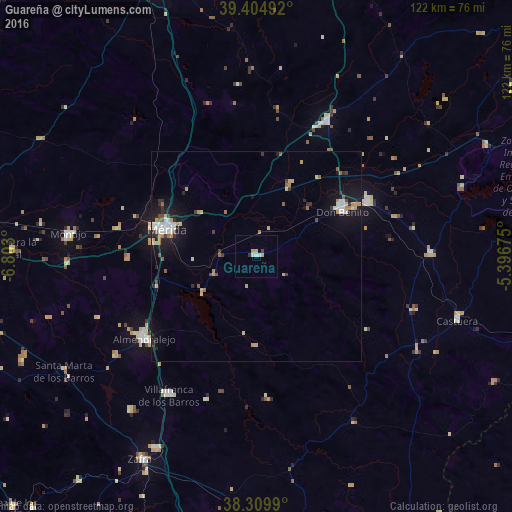
Analysis of Guareña night lights 2016
Square area 10x10 km:
 0.85%
0.85%90-99
1.19%80-89
1.36%70-79
0.68%60-69
0%50-59
0%40-49
0.34%30-39
1.02%20-29
0%10-19
0%0-9
94.56%Square area 50x50 km:
0.51%90-99
0.5%80-89
0.57%70-79
0.43%60-69
0.45%50-59
0.33%40-49
0.29%30-39
0.47%20-29
0.56%10-19
3.13%0-9
92.75%Clear (daylight) street map image can be seen on geolist.org.
Map coordinates:
39° 24' 17.7" North, 6° 48' 10.8" West
38° 51' 34.3" North, 6° 5' 59.5" West
38° 18' 35.6" North, 5° 23' 48.3" West
Some cities around Guareña sort by population:
• Mérida
22 km =13.7 mi,  286°
286°
• Don Benito
23.3 km =14.5 mi,  62°
62°
• Almendralejo
33.1 km =20.6 mi,  233°
233°
• Villanueva de la Serena
29.2 km =18.1 mi, 63°
• Villafranca de los Barros
39.1 km =24.3 mi,  211°
211°
• Miajadas
36.4 km =22.6 mi,  27°
27°
• Calamonte
25.1 km =15.6 mi,  277°
277°
• Quintana de la Serena
39.1 km =24.3 mi,  108°
108°
2516896 (p: 7,330)
Sources (retrieved 2019-11-25):
» Earth at Night: Flat Maps 2012, 2016