Barri Gòtic night lights from space
Night Light of Barri Gòtic (Catalonia) from space (Spain) Src. Average luminocity for 10x10km area is 81.7194% and for 50x50km: 40.3191%.
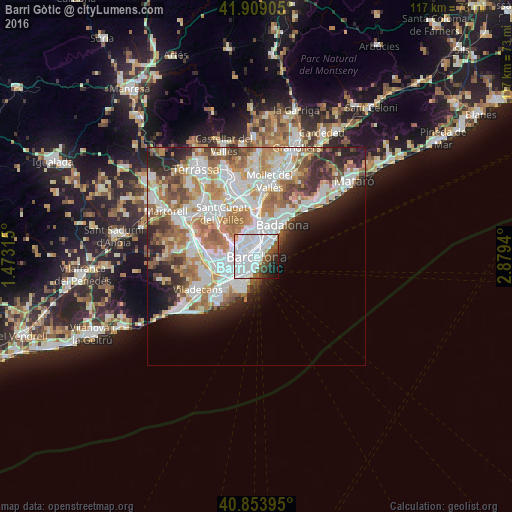
Analysis of Barri Gòtic night lights 2016
Square area 10x10 km:
 50.34%
90-99
20.07%80-89
0.68%70-79
1.02%60-69
0.34%50-59
8.33%40-49
5.27%30-39
3.57%20-29
6.12%10-19
4.08%0-9
0.17%Square area 50x50 km:
11.33%90-99
9.92%80-89
3.73%70-79
4.71%60-69
7%50-59
5.24%40-49
3.11%30-39
3.49%20-29
6.52%10-19
5.72%0-9
39.23%Clear (daylight) street map image can be seen on geolist.org.
Map coordinates:
41° 54' 32.6" North, 1° 28' 23.3" East
41° 23' 1.1" North, 2° 10' 34.6" East
40° 51' 14.2" North, 2° 52' 45.8" East
Some cities around Barri Gòtic sort by population:
• Eixample
1.3 km =0.8 mi,  296°
296°
• Ciutat Vella
0.5 km =0.3 mi,  214°
214°
• el Raval
0.7 km =0.4 mi,  240°
240°
• Poble Sec
1.5 km =0.9 mi,  226°
226°
• Sant Antoni
1.5 km =0.9 mi,  248°
248°
• Fort Pienc
1.2 km =0.7 mi,  12°
12°
• Sant Pere, Santa Caterina i La Ribera
0.4 km =0.2 mi,  77°
77°
• la Barceloneta
1.2 km =0.7 mi,  110°
110°
6544577 (p: 15,876)
Sources (retrieved 2019-11-25):
» Earth at Night: Flat Maps 2012, 2016