Ayora night lights from space
Night Light of Ayora (Valencia) from space (Spain) Src. Average luminocity for 10x10km area is 3.3961% and for 50x50km: 0.9374%.
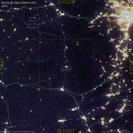
Analysis of Ayora night lights 2016
Square area 10x10 km:
 0.32%
0.32%90-99
0.65%80-89
0.97%70-79
0.65%60-69
0%50-59
0%40-49
0.65%30-39
0.65%20-29
0%10-19
0.65%0-9
95.45%Square area 50x50 km:
0.05%90-99
0.17%80-89
0.13%70-79
0.13%60-69
0.19%50-59
0.11%40-49
0.07%30-39
0.28%20-29
0.21%10-19
0.08%0-9
98.6%Clear (daylight) street map image can be seen on geolist.org.
Map coordinates:
39° 36' 8.6" North, 1° 45' 34.1" West
39° 3' 30.7" North, 1° 3' 22.9" West
38° 30' 37.5" North, 0° 21' 11.6" West
Some cities around Ayora sort by population:
• Ontinyent
47 km =29.2 mi,  124°
124°
• Almansa
21.3 km =13.2 mi,  189°
189°
• Canals
42.1 km =26.2 mi,  104°
104°
• Alberic
47 km =29.2 mi,  82°
82°
• Caudete
39.6 km =24.6 mi,  171°
171°
• Buñol
46.2 km =28.7 mi,  30°
30°
• L'Olleria
46.5 km =28.9 mi,  109°
109°
• Enguera
33.1 km =20.6 mi, 105°
2521451 (p: 5,508)
Sources (retrieved 2019-11-25):
» Earth at Night: Flat Maps 2012, 2016