Almussafes night lights from space
Night Light of Almussafes (Valencia) from space (Spain) Src. Average luminocity for 10x10km area is 40.0731% and for 50x50km: 24.418%.
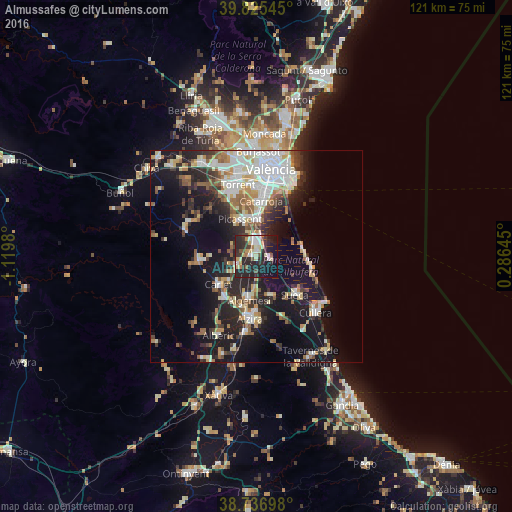
Analysis of Almussafes night lights 2016
Square area 10x10 km:
100  4.76%
4.76%
90-99 7.31%
80-89 5.95%
70-79 6.12%
60-69 2.04%
50-59 2.72%
40-49 3.91%
30-39 11.22%
20-29 27.89%
10-19 23.3%
0-9 4.76%
4.76%90-99
7.31%80-89
5.95%70-79
6.12%60-69
2.04%50-59
2.72%40-49
3.91%30-39
11.22%20-29
27.89%10-19
23.3%0-9
4.76%Square area 50x50 km:
100 4.87%
90-99 4.77%
80-89 2.58%
70-79 2.64%
60-69 2.77%
50-59 2.77%
40-49 2.17%
30-39 3.56%
20-29 7.26%
10-19 17.15%
0-9 49.47%
4.87%90-99
4.77%80-89
2.58%70-79
2.64%60-69
2.77%50-59
2.77%40-49
2.17%30-39
3.56%20-29
7.26%10-19
17.15%0-9
49.47%Clear (daylight) street map image can be seen on geolist.org.
Map coordinates:
39° 49' 31.6" North, 1° 7' 11.3" West
39° 16' 60" North, 0° 25' 0" West
38° 44' 13.1" North, 0° 17' 11.2" East
Some cities around Almussafes sort by population:
• Algemesí
10.5 km =6.5 mi,  189°
189°
• Picassent
9.6 km =6 mi,  337°
337°
• Silla
8.8 km =5.5 mi,  2°
2°
• Carlet
11 km =6.8 mi,  235°
235°
• Alginet
4.7 km =2.9 mi,  246°
246°
• Benifaió
0.8 km =0.5 mi,  278°
278°
• Alcàsser
9.7 km =6 mi,  345°
345°
• Guadassuar
12 km =7.5 mi,  206°
206°
2521845 (p: 7,459)
Sources (retrieved 2019-11-25):
» Earth at Night: Flat Maps 2012, 2016