Picassent night lights from space
Night Light of Picassent (Valencia) from space (Spain) Src. Average luminocity for 10x10km area is 54.6616% and for 50x50km: 29.2712%.
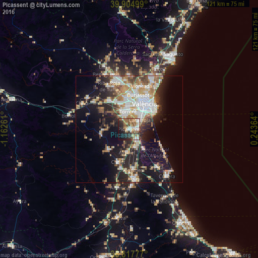
Analysis of Picassent night lights 2016
Square area 10x10 km:
100  10.37%
90-99 9.52%
80-89 6.63%
70-79 6.8%
60-69 12.41%
50-59 10.2%
40-49 6.97%
30-39 6.63%
20-29 14.46%
10-19 13.95%
0-9 2.04%
10.37%90-99
9.52%80-89
6.63%70-79
6.8%60-69
12.41%50-59
10.2%40-49
6.97%30-39
6.63%20-29
14.46%10-19
13.95%0-9
2.04%Square area 50x50 km:
100 5.93%
90-99 6.03%
80-89 3.3%
70-79 3.74%
60-69 3.77%
50-59 3.51%
40-49 2.78%
30-39 3.79%
20-29 7.89%
10-19 15.27%
0-9 44%
5.93%90-99
6.03%80-89
3.3%70-79
3.74%60-69
3.77%50-59
3.51%40-49
2.78%30-39
3.79%20-29
7.89%10-19
15.27%0-9
44%Clear (daylight) street map image can be seen on geolist.org.
Map coordinates:
39° 54' 18" North, 1° 9' 45.4" West
39° 21' 48.6" North, 0° 27' 34.2" West
38° 49' 4" North, 0° 14' 37.1" East
Some cities around Picassent sort by population:
• Torrent
8.2 km =5.1 mi,  356°
356°
• Catarroja
6.5 km =4 mi,  51°
51°
• Paiporta
8 km =5 mi,  26°
26°
• Silla
4.1 km =2.5 mi,  91°
91°
• Albal
5.5 km =3.4 mi,  42°
42°
• Benetússer
8.5 km =5.3 mi, 39°
• Picanya
8.1 km =5 mi,  16°
16°
• Alcàsser
1.4 km =0.9 mi,  69°
69°
2512620 (p: 19,786)
Sources (retrieved 2019-11-25):
» Earth at Night: Flat Maps 2012, 2016