Alginet night lights from space
Night Light of Alginet (Valencia) from space (Spain) Src. Average luminocity for 10x10km area is 39.7738% and for 50x50km: 23.6883%.
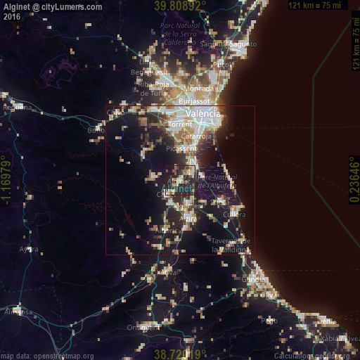
Analysis of Alginet night lights 2016
Square area 10x10 km:
100  2.72%
2.72%
90-99 5.27%
80-89 6.29%
70-79 6.97%
60-69 3.74%
50-59 4.08%
40-49 6.46%
30-39 9.52%
20-29 33.16%
10-19 19.73%
0-9 2.04%
2.72%90-99
5.27%80-89
6.29%70-79
6.97%60-69
3.74%50-59
4.08%40-49
6.46%30-39
9.52%20-29
33.16%10-19
19.73%0-9
2.04%Square area 50x50 km:
100 4.31%
90-99 4.49%
80-89 2.54%
70-79 2.6%
60-69 2.81%
50-59 2.82%
40-49 2.08%
30-39 3.46%
20-29 7.12%
10-19 17.78%
0-9 49.97%
4.31%90-99
4.49%80-89
2.54%70-79
2.6%60-69
2.81%50-59
2.82%40-49
2.08%30-39
3.46%20-29
7.12%10-19
17.78%0-9
49.97%Clear (daylight) street map image can be seen on geolist.org.
Map coordinates:
39° 48' 32.1" North, 1° 10' 11.2" West
39° 16' 0" North, 0° 28' 0" West
38° 43' 12.7" North, 0° 14' 11.3" East
Some cities around Alginet sort by population:
• Algemesí
8.9 km =5.5 mi,  162°
162°
• Picassent
10.8 km =6.7 mi,  3°
3°
• Carlet
6.5 km =4 mi,  226°
226°
• Benifaió
4 km =2.5 mi,  60°
60°
• L'Alcúdia
8.4 km =5.2 mi,  203°
203°
• Alcàsser
11.4 km =7.1 mi,  9°
9°
• Almussafes
4.7 km =2.9 mi,  66°
66°
• Guadassuar
9 km =5.6 mi,  186°
186°
2522007 (p: 13,226)
Sources (retrieved 2019-11-25):
» Earth at Night: Flat Maps 2012, 2016