Saue night lights from space
Night Light of Saue (Harjumaa) from space (Estonia) Src. Average luminocity for 10x10km area is 18.8442% and for 50x50km: 13.3477%.
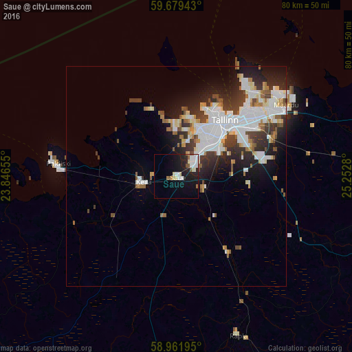
Analysis of Saue night lights 2016
Square area 10x10 km:
100  3.68%
3.68%
90-99 4.98%
80-89 2.38%
70-79 0.54%
60-69 1.08%
50-59 1.95%
40-49 0.54%
30-39 0%
20-29 5.3%
10-19 18.83%
0-9 60.71%
3.68%90-99
4.98%80-89
2.38%70-79
0.54%60-69
1.08%50-59
1.95%40-49
0.54%30-39
0%20-29
5.3%10-19
18.83%0-9
60.71%Square area 50x50 km:
100 3.66%
90-99 3.38%
80-89 1.14%
70-79 0.81%
60-69 1.22%
50-59 1.06%
40-49 1.28%
30-39 2.17%
20-29 3.35%
10-19 5.54%
0-9 76.39%
3.66%90-99
3.38%80-89
1.14%70-79
0.81%60-69
1.22%50-59
1.06%40-49
1.28%30-39
2.17%20-29
3.35%10-19
5.54%0-9
76.39%Clear (daylight) street map image can be seen on geolist.org.
Map coordinates:
59° 40' 45.9" North, 23° 50' 47.6" East
59° 19' 21.3" North, 24° 32' 58.8" East
58° 57' 43" North, 25° 15' 10.1" East
Some cities around Saue sort by population:
• Tallinn
17.2 km =10.7 mi,  42°
42°
• Maardu
29.2 km =18.1 mi,  57°
57°
• Haapsalu
71.3 km =44.3 mi,  233°
233°
• Paide
75.3 km =46.8 mi,  130°
130°
• Keila
8 km =5 mi,  254°
254°
• Tapa
80.3 km =49.9 mi,  94°
94°
• Türi
76.2 km =47.3 mi,  138°
138°
• Rapla
37.7 km =23.4 mi,  158°
158°
588780 (p: 5,022)
Sources (retrieved 2019-11-25):
» Earth at Night: Flat Maps 2012, 2016