San Miguel de Salcedo night lights from space
Night Light of San Miguel de Salcedo (Cotopaxi) from space (Ecuador) Src. Average luminocity for 10x10km area is 40.9156% and for 50x50km: 16.8125%.
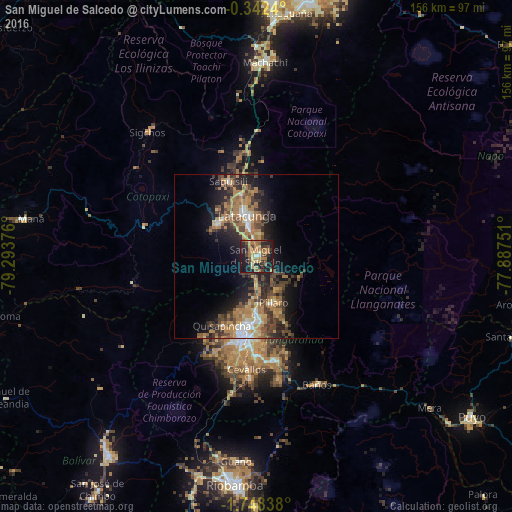
Analysis of San Miguel de Salcedo night lights 2016
Square area 10x10 km:
 0.87%
0.87%90-99
1.08%80-89
5.63%70-79
6.71%60-69
17.75%50-59
7.14%40-49
5.19%30-39
9.74%20-29
16.02%10-19
28.35%0-9
1.52%Square area 50x50 km:
1.33%90-99
1.33%80-89
1.56%70-79
2.86%60-69
5.47%50-59
2.06%40-49
3.71%30-39
3.78%20-29
4.72%10-19
9.58%0-9
63.6%Clear (daylight) street map image can be seen on geolist.org.
Map coordinates:
0° 20' 32.6" South, 79° 17' 37.5" West
1° 2' 43.7" South, 78° 35' 26.3" West
1° 44' 54.2" South, 77° 53' 15" West
Some cities around San Miguel de Salcedo sort by population:
• Ambato
22.8 km =14.2 mi,  187°
187°
• Latacunga
12.6 km =7.8 mi,  347°
347°
• Machachi
59.6 km =37 mi,  2°
2°
• Pelileo
32.1 km =19.9 mi,  170°
170°
• Pujilí
15.3 km =9.5 mi,  309°
309°
• Guano
62.7 km =39 mi,  184°
184°
• Baños
43.3 km =26.9 mi,  154°
154°
• Píllaro
15.1 km =9.4 mi,  161°
161°
3651613 (p: 10,838)
Sources (retrieved 2019-11-25):
» Earth at Night: Flat Maps 2012, 2016