Gualaceo night lights from space
Night Light of Gualaceo (Azuay) from space (Ecuador) Src. Average luminocity for 10x10km area is 42.7944% and for 50x50km: 19.2091%.
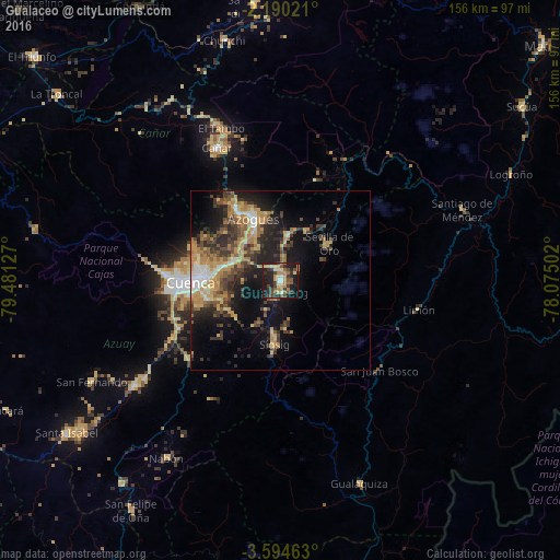
Analysis of Gualaceo night lights 2016
Square area 10x10 km:
 3.03%
3.03%90-99
2.16%80-89
10.61%70-79
8.23%60-69
6.28%50-59
6.28%40-49
10.39%30-39
8.66%20-29
15.15%10-19
27.71%0-9
1.52%Square area 50x50 km:
1.39%90-99
1.74%80-89
2.81%70-79
4.18%60-69
3.23%50-59
2.73%40-49
3.52%30-39
4.6%20-29
5.7%10-19
10.72%0-9
59.37%Clear (daylight) street map image can be seen on geolist.org.
Map coordinates:
2° 11' 24.8" South, 79° 28' 52.6" West
2° 53' 33.5" South, 78° 46' 41.3" West
3° 35' 40.7" South, 78° 4' 30.1" West
Some cities around Gualaceo sort by population:
• Cuenca
25.2 km =15.7 mi,  267°
267°
• La Troncal
81.3 km =50.5 mi,  309°
309°
• Azogues
18.7 km =11.6 mi,  335°
335°
• Naranjal
96.4 km =59.9 mi,  284°
284°
• Macas
98.5 km =61.2 mi,  48°
48°
• Alausí
77 km =47.8 mi,  354°
354°
• Cañar
41 km =25.5 mi,  334°
334°
• Sucúa
82.9 km =51.5 mi, 54°
3657670 (p: 17,122)
Sources (retrieved 2019-11-25):
» Earth at Night: Flat Maps 2012, 2016