’Aïn el Berd night lights from space
Night Light of ’Aïn el Berd (Sidi Bel Abbès) from space (Algeria) Src. Average luminocity for 10x10km area is 4.3736% and for 50x50km: 6.8934%.
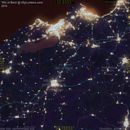
Analysis of ’Aïn el Berd night lights 2016
Square area 10x10 km:
 0.37%
0.37%90-99
0.73%80-89
1.1%70-79
0%60-69
0.92%50-59
0.37%40-49
0.92%30-39
0.73%20-29
0%10-19
0%0-9
94.87%Square area 50x50 km:
0.62%90-99
0.91%80-89
1.12%70-79
0.78%60-69
0.84%50-59
0.76%40-49
0.59%30-39
1.54%20-29
1.43%10-19
6.05%0-9
85.36%Clear (daylight) street map image can be seen on geolist.org.
Map coordinates:
35° 56' 7.1" North, 1° 12' 57.3" West
35° 21' 50.2" North, 0° 30' 46" West
34° 47' 18.7" North, 0° 11' 25.2" East
Some cities around ’Aïn el Berd sort by population:
• Oran
38.9 km =24.2 mi,  343°
343°
• Sidi Bel Abbès
22.1 km =13.7 mi,  208°
208°
• Es Senia
33.1 km =20.6 mi, 342°
• Bir el Djir
39.7 km =24.7 mi,  355°
355°
• Sig
34.2 km =21.3 mi,  57°
57°
• Hammam Bou Hadjar
41.3 km =25.7 mi,  272°
272°
• Sidi ech Chahmi
32.8 km =20.4 mi, 358°
• Sfizef
28.3 km =17.6 mi,  120°
120°
2508180 (p: 16,548)
Sources (retrieved 2019-11-25):
» Earth at Night: Flat Maps 2012, 2016