Hammam Bou Hadjar night lights from space
Night Light of Hammam Bou Hadjar (Aïn Témouchent) from space (Algeria) Src. Average luminocity for 10x10km area is 7.9799% and for 50x50km: 5.5291%.
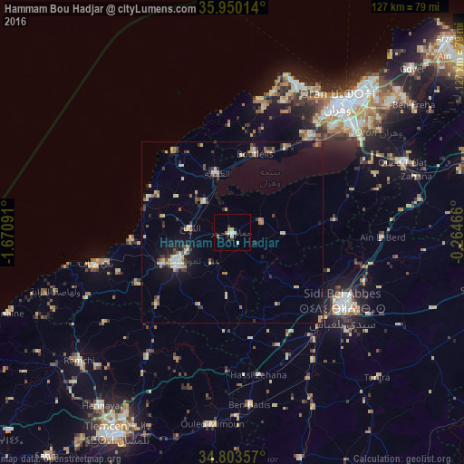

Analysis of Hammam Bou Hadjar night lights 2016
Square area 10x10 km:
 0.92%
0.92%90-99
0.73%80-89
2.75%70-79
0.73%60-69
1.47%50-59
0%40-49
0%30-39
1.83%20-29
0.37%10-19
0.55%0-9
90.66%Square area 50x50 km:
0.45%90-99
0.64%80-89
1.12%70-79
0.52%60-69
0.85%50-59
0.34%40-49
0.62%30-39
1.05%20-29
0.96%10-19
2.6%0-9
90.85%Clear (daylight) street map image can be seen on geolist.org.
Map coordinates:
35° 57' 0.5" North, 1° 40' 15.3" West
35° 22' 44" North, 0° 58' 4" West
34° 48' 12.9" North, 0° 15' 52.8" West
Some cities around Hammam Bou Hadjar sort by population:
• Sidi Bel Abbès
37.1 km =23.1 mi,  124°
124°
• Aïn Temouchent
18.1 km =11.2 mi,  239°
239°
• Beni Saf
38.6 km =24 mi,  257°
257°
• El Amria
16.8 km =10.4 mi,  344°
344°
• Bou Tlelis
22.4 km =13.9 mi,  15°
15°
• Sidi Abdelli
37.7 km =23.4 mi,  204°
204°
• Bensekrane
41.1 km =25.5 mi,  214°
214°
• El Malah
11.4 km =7.1 mi,  277°
277°
2494554 (p: 35,896)
Sources (retrieved 2019-11-25):
» Earth at Night: Flat Maps 2012, 2016