Yaguate night lights from space
Night Light of Yaguate (San Cristóbal) from space (Dominican Republic) Src. Average luminocity for 10x10km area is 27.4835% and for 50x50km: 15.8981%.
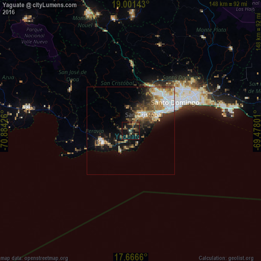
Analysis of Yaguate night lights 2016
Square area 10x10 km:
 0%
0%90-99
0.83%80-89
2.48%70-79
4.13%60-69
6.82%50-59
2.27%40-49
8.88%30-39
11.16%20-29
6.82%10-19
44.63%0-9
11.98%Square area 50x50 km:
2.8%90-99
2.58%80-89
1.57%70-79
1.93%60-69
3.14%50-59
1.65%40-49
2.79%30-39
3.31%20-29
2.68%10-19
8.8%0-9
68.74%Clear (daylight) street map image can be seen on geolist.org.
Map coordinates:
19° 0' 5.1" North, 70° 53' 3.3" West
18° 20' 7.1" North, 70° 10' 52.1" West
17° 39' 59.8" North, 69° 28' 40.8" West
Some cities around Yaguate sort by population:
• Santo Domingo Oeste
26.5 km =16.5 mi,  46°
46°
• San Cristóbal
12.5 km =7.8 mi,  43°
43°
• Bajos de Haina
18 km =11.2 mi,  60°
60°
• Baní
17.1 km =10.6 mi,  248°
248°
• Cambita Garabitos
13.4 km =8.3 mi,  351°
351°
• San Gregorio de Nigua
11.6 km =7.2 mi, 62°
• Paya
14.6 km =9.1 mi,  235°
235°
• Nizao
10.3 km =6.4 mi,  197°
197°
3491807 (p: 5,610)
Sources (retrieved 2019-11-25):
» Earth at Night: Flat Maps 2012, 2016