Sabana Iglesia night lights from space
Night Light of Sabana Iglesia (Santiago) from space (Dominican Republic) Src. Average luminocity for 10x10km area is 5.3388% and for 50x50km: 15.5555%.
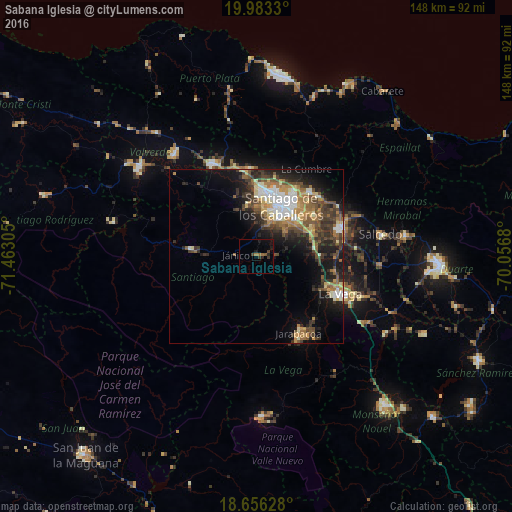
Analysis of Sabana Iglesia night lights 2016
Square area 10x10 km:
 0%
0%90-99
0%80-89
0%70-79
0%60-69
1.45%50-59
1.86%40-49
0.62%30-39
2.69%20-29
1.45%10-19
4.13%0-9
87.81%Square area 50x50 km:
1.79%90-99
2.25%80-89
1.67%70-79
1.91%60-69
3%50-59
2.22%40-49
3.46%30-39
3.67%20-29
3.96%10-19
8.41%0-9
67.66%Clear (daylight) street map image can be seen on geolist.org.
Map coordinates:
19° 58' 59.9" North, 71° 27' 47" West
19° 19' 16.1" North, 70° 45' 35.7" West
18° 39' 22.6" North, 70° 3' 24.5" West
Some cities around Sabana Iglesia sort by population:
• Santiago de los Caballeros
15.9 km =9.9 mi,  24°
24°
• Concepción de La Vega
26.6 km =16.5 mi,  114°
114°
• Moca
25.8 km =16 mi,  71°
71°
• Jarabacoa
26.2 km =16.3 mi,  150°
150°
• Tamboril
24 km =14.9 mi,  40°
40°
• Villa González
24.6 km =15.3 mi,  352°
352°
• San José de Las Matas
18.8 km =11.7 mi,  276°
276°
• Licey al Medio
20.9 km =13 mi,  53°
53°
3493478 (p: 5,135)
Sources (retrieved 2019-11-25):
» Earth at Night: Flat Maps 2012, 2016