Estebanía night lights from space
Night Light of Estebanía (Azua) from space (Dominican Republic) Src. Average luminocity for 10x10km area is 3.4483% and for 50x50km: 2.2892%.
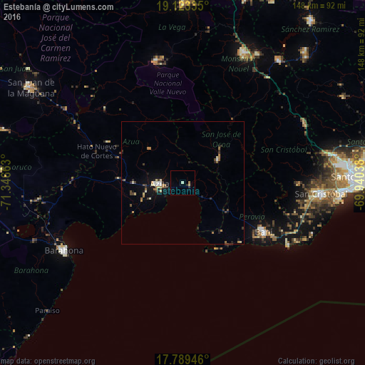
Analysis of Estebanía night lights 2016
Square area 10x10 km:
 0%
0%90-99
1.03%80-89
0.62%70-79
0%60-69
0.83%50-59
0%40-49
0%30-39
1.03%20-29
0.62%10-19
0%0-9
95.87%Square area 50x50 km:
0.11%90-99
0.32%80-89
0.28%70-79
0.22%60-69
0.54%50-59
0.18%40-49
0.32%30-39
0.54%20-29
0.39%10-19
1.24%0-9
95.84%Clear (daylight) street map image can be seen on geolist.org.
Map coordinates:
19° 7' 24.1" North, 71° 20' 47.9" West
18° 27' 27.7" North, 70° 38' 36.6" West
17° 47' 22.1" North, 69° 56' 25.4" West
Some cities around Estebanía sort by population:
• Baní
38.4 km =23.9 mi,  121°
121°
• Azua
9.7 km =6 mi,  267°
267°
• San José de Ocoa
17.5 km =10.9 mi,  55°
55°
• Cambita Garabitos
46.9 km =29.1 mi,  90°
90°
• Padre Las Casas
43.6 km =27.1 mi,  314°
314°
• Peralta
19.2 km =11.9 mi,  315°
315°
• Paya
42.7 km =26.5 mi, 120°
• Yayas de Viajama
34.2 km =21.3 mi,  299°
299°
3505825 (p: 5,591)
Sources (retrieved 2019-11-25):
» Earth at Night: Flat Maps 2012, 2016