Zimmern ob Rottweil night lights from space
Night Light of Zimmern ob Rottweil (Baden-Württemberg) from space (Germany) Src. Average luminocity for 10x10km area is 13.6042% and for 50x50km: 5.2002%.
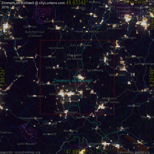
Analysis of Zimmern ob Rottweil night lights 2016
Square area 10x10 km:
 1.04%
1.04%90-99
2.38%80-89
2.83%70-79
1.34%60-69
0.74%50-59
1.79%40-49
1.19%30-39
2.68%20-29
0.74%10-19
7.89%0-9
77.38%Square area 50x50 km:
0.45%90-99
0.78%80-89
0.42%70-79
0.54%60-69
0.54%50-59
0.73%40-49
0.86%30-39
0.95%20-29
1.02%10-19
3.86%0-9
89.86%Clear (daylight) street map image can be seen on geolist.org.
Map coordinates:
48° 38' 0.3" North, 7° 53' 28.5" East
48° 9' 59.8" North, 8° 35' 39.7" East
47° 41' 43.8" North, 9° 17' 51" East
Some cities around Zimmern ob Rottweil sort by population:
• Villingen-Schwenningen
13.8 km =8.6 mi,  212°
212°
• Rottweil
2.4 km =1.5 mi,  86°
86°
• Trossingen
10.7 km =6.6 mi,  159°
159°
• Aldingen
10.8 km =6.7 mi,  133°
133°
• Königsfeld im Schwarzwald
13.3 km =8.3 mi,  256°
256°
• Deißlingen
6.1 km =3.8 mi,  170°
170°
• Dunningen
8.3 km =5.2 mi,  307°
307°
• Niedereschach
5.8 km =3.6 mi,  230°
230°
2804159 (p: 6,061)
Sources (retrieved 2019-11-25):
» Earth at Night: Flat Maps 2012, 2016