Dunningen night lights from space
Night Light of Dunningen (Baden-Württemberg) from space (Germany) Src. Average luminocity for 10x10km area is 0.4405% and for 50x50km: 4.3486%.
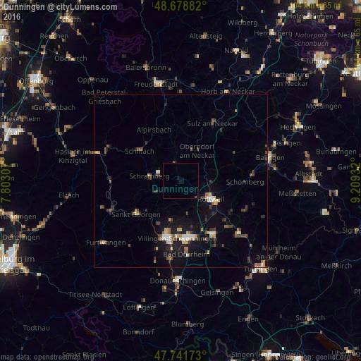
Analysis of Dunningen night lights 2016
Square area 10x10 km:
 0%
0%90-99
0%80-89
0%70-79
0%60-69
0%50-59
0%40-49
0.3%30-39
0%20-29
0%10-19
0.6%0-9
99.11%Square area 50x50 km:
0.32%90-99
0.58%80-89
0.35%70-79
0.5%60-69
0.49%50-59
0.72%40-49
0.75%30-39
0.76%20-29
0.88%10-19
3.62%0-9
91.05%Clear (daylight) street map image can be seen on geolist.org.
Map coordinates:
48° 40' 43.8" North, 7° 48' 11.1" East
48° 12' 44.7" North, 8° 30' 22.3" East
47° 44' 30.2" North, 9° 12' 33.6" East
Some cities around Dunningen sort by population:
• Rottweil
10.2 km =6.3 mi,  118°
118°
• Schramberg
9 km =5.6 mi,  278°
278°
• Oberndorf
10 km =6.2 mi,  29°
29°
• Königsfeld im Schwarzwald
10.5 km =6.5 mi,  217°
217°
• Dornhan
15.3 km =9.5 mi,  0°
0°
• Deißlingen
13.4 km =8.3 mi,  146°
146°
• Zimmern ob Rottweil
8.3 km =5.2 mi,  127°
127°
• Niedereschach
9 km =5.6 mi,  167°
167°
2934560 (p: 6,032)
Sources (retrieved 2019-11-25):
» Earth at Night: Flat Maps 2012, 2016