Königsfeld im Schwarzwald night lights from space
Night Light of Königsfeld im Schwarzwald (Baden-Württemberg) from space (Germany) Src. Average luminocity for 10x10km area is 3.1533% and for 50x50km: 4.5006%.
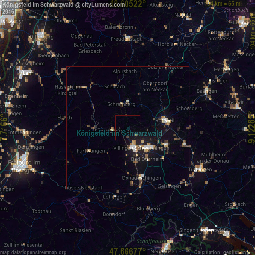
Analysis of Königsfeld im Schwarzwald night lights 2016
Square area 10x10 km:
 0%
0%90-99
0%80-89
0%70-79
0.6%60-69
0%50-59
0%40-49
0.45%30-39
1.79%20-29
0.15%10-19
5.06%0-9
91.96%Square area 50x50 km:
0.34%90-99
0.65%80-89
0.37%70-79
0.5%60-69
0.44%50-59
0.78%40-49
0.76%30-39
0.92%20-29
0.86%10-19
3.51%0-9
90.86%Clear (daylight) street map image can be seen on geolist.org.
Map coordinates:
48° 36' 18.8" North, 7° 42' 59.8" East
48° 8' 17.3" North, 8° 25' 11" East
47° 40' 0.4" North, 9° 7' 22.3" East
Some cities around Königsfeld im Schwarzwald sort by population:
• Villingen-Schwenningen
10.1 km =6.3 mi,  146°
146°
• Schramberg
9.9 km =6.2 mi,  345°
345°
• Sankt Georgen im Schwarzwald
6.4 km =4 mi,  258°
258°
• Deißlingen
14.2 km =8.8 mi,  101°
101°
• Zimmern ob Rottweil
13.3 km =8.3 mi,  76°
76°
• Dunningen
10.5 km =6.5 mi,  37°
37°
• Niedereschach
8.4 km =5.2 mi,  93°
93°
• Triberg
13.9 km =8.6 mi,  267°
267°
2885888 (p: 6,212)
Sources (retrieved 2019-11-25):
» Earth at Night: Flat Maps 2012, 2016