Deißlingen night lights from space
Night Light of Deißlingen (Baden-Württemberg) from space (Germany) Src. Average luminocity for 10x10km area is 14.0223% and for 50x50km: 5.4781%.
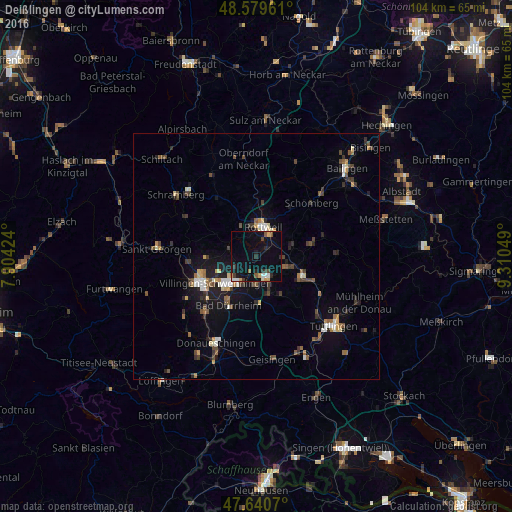
Analysis of Deißlingen night lights 2016
Square area 10x10 km:
 1.04%
1.04%90-99
1.79%80-89
0.45%70-79
1.64%60-69
0.89%50-59
1.79%40-49
1.19%30-39
2.38%20-29
3.13%10-19
15.03%0-9
70.68%Square area 50x50 km:
0.45%90-99
0.81%80-89
0.42%70-79
0.58%60-69
0.6%50-59
0.81%40-49
0.97%30-39
1.03%20-29
1.02%10-19
3.84%0-9
89.48%Clear (daylight) street map image can be seen on geolist.org.
Map coordinates:
48° 34' 46.6" North, 7° 54' 15.3" East
48° 6' 44.3" North, 8° 36' 26.5" East
47° 38' 26.5" North, 9° 18' 37.8" East
Some cities around Deißlingen sort by population:
• Villingen-Schwenningen
10.1 km =6.3 mi,  236°
236°
• Rottweil
6.3 km =3.9 mi,  13°
13°
• Trossingen
4.8 km =3 mi,  145°
145°
• Bad Dürrheim
11.7 km =7.3 mi,  209°
209°
• Spaichingen
10.4 km =6.5 mi,  113°
113°
• Aldingen
7 km =4.3 mi,  101°
101°
• Zimmern ob Rottweil
6.1 km =3.8 mi,  350°
350°
• Niedereschach
6 km =3.7 mi,  293°
293°
2938403 (p: 6,129)
Sources (retrieved 2019-11-25):
» Earth at Night: Flat Maps 2012, 2016