Wittichenau night lights from space
Night Light of Wittichenau (Saxony) from space (Germany) Src. Average luminocity for 10x10km area is 1.1527% and for 50x50km: 2.9394%.
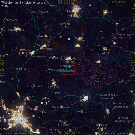
Analysis of Wittichenau night lights 2016
Square area 10x10 km:
 0%
0%90-99
0%80-89
0%70-79
0%60-69
0.56%50-59
0%40-49
0%30-39
0.28%20-29
0%10-19
0%0-9
99.16%Square area 50x50 km:
0.36%90-99
0.5%80-89
0.23%70-79
0.33%60-69
0.37%50-59
0.46%40-49
0.37%30-39
0.59%20-29
0.22%10-19
0.88%0-9
95.69%Clear (daylight) street map image can be seen on geolist.org.
Map coordinates:
51° 49' 18" North, 13° 32' 27.3" East
51° 23' 5.9" North, 14° 14' 38.5" East
50° 56' 38.5" North, 14° 56' 49.8" East
Some cities around Wittichenau sort by population:
• Hoyerswerda
5.9 km =3.7 mi,  354°
354°
• Bautzen
26.3 km =16.3 mi,  149°
149°
• Senftenberg
22.9 km =14.2 mi,  312°
312°
• Kamenz
16.7 km =10.4 mi,  218°
218°
• Großräschen
27.7 km =17.2 mi,  324°
324°
• Schipkau
28.2 km =17.5 mi,  301°
301°
• Bernsdorf
12.2 km =7.6 mi,  264°
264°
• Haselbachtal
22.5 km =14 mi, 222°
2807265 (p: 6,261)
Sources (retrieved 2019-11-25):
» Earth at Night: Flat Maps 2012, 2016