Kamenz night lights from space
Night Light of Kamenz (Saxony) from space (Germany) Src. Average luminocity for 10x10km area is 5.7423% and for 50x50km: 4.2748%.
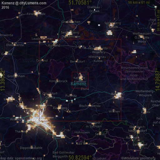
Analysis of Kamenz night lights 2016
Square area 10x10 km:
 0%
0%90-99
0.14%80-89
0.56%70-79
2.1%60-69
1.12%50-59
1.54%40-49
1.68%30-39
0.7%20-29
0.56%10-19
0%0-9
91.6%Square area 50x50 km:
0.66%90-99
0.68%80-89
0.33%70-79
0.49%60-69
0.62%50-59
0.68%40-49
0.59%30-39
0.87%20-29
0.65%10-19
1.72%0-9
92.71%Clear (daylight) street map image can be seen on geolist.org.
Map coordinates:
51° 42' 20.9" North, 13° 23' 26.2" East
51° 16' 4.7" North, 14° 5' 37.5" East
50° 49' 33.4" North, 14° 47' 48.7" East
Some cities around Kamenz sort by population:
• Hoyerswerda
21.3 km =13.2 mi,  27°
27°
• Radeberg
21.6 km =13.4 mi,  215°
215°
• Bischofswerda
16.7 km =10.4 mi,  158°
158°
• Ottendorf-Okrilla
20.4 km =12.7 mi,  242°
242°
• Großröhrsdorf
14.6 km =9.1 mi,  200°
200°
• Wittichenau
16.7 km =10.4 mi,  38°
38°
• Bernsdorf
11.9 km =7.4 mi,  351°
351°
• Haselbachtal
5.9 km =3.7 mi,  232°
232°
2893437 (p: 18,270)
Sources (retrieved 2019-11-25):
» Earth at Night: Flat Maps 2012, 2016