Haselbachtal night lights from space
Night Light of Haselbachtal (Saxony) from space (Germany) Src. Average luminocity for 10x10km area is 0.8459% and for 50x50km: 6.4124%.
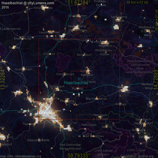
Analysis of Haselbachtal night lights 2016
Square area 10x10 km:
 0%
0%90-99
0%80-89
0%70-79
0.56%60-69
0%50-59
0%40-49
0%30-39
0.42%20-29
0.14%10-19
0%0-9
98.88%Square area 50x50 km:
1.32%90-99
1.3%80-89
0.52%70-79
0.8%60-69
0.79%50-59
1.06%40-49
0.83%30-39
0.96%20-29
0.94%10-19
2.04%0-9
89.44%Clear (daylight) street map image can be seen on geolist.org.
Map coordinates:
51° 40' 25.8" North, 13° 19' 21.5" East
51° 14' 8.5" North, 14° 1' 32.7" East
50° 47' 36.1" North, 14° 43' 44" East
Some cities around Haselbachtal sort by population:
• Radeberg
16 km =9.9 mi,  209°
209°
• Kamenz
5.9 km =3.7 mi,  52°
52°
• Bischofswerda
16.1 km =10 mi,  138°
138°
• Ottendorf-Okrilla
14.6 km =9.1 mi,  246°
246°
• Radeburg
20.9 km =13 mi,  263°
263°
• Großröhrsdorf
10.1 km =6.3 mi,  182°
182°
• Stolpen
21.1 km =13.1 mi,  169°
169°
• Bernsdorf
15.6 km =9.7 mi,  11°
11°
7302786 (p: 0)
Sources (retrieved 2019-11-25):
» Earth at Night: Flat Maps 2012, 2016