Windischeschenbach night lights from space
Night Light of Windischeschenbach (Bavaria) from space (Germany) Src. Average luminocity for 10x10km area is 0.1444% and for 50x50km: 1.6683%.
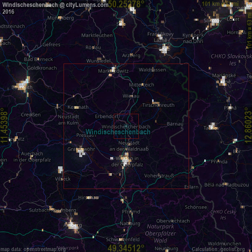
Analysis of Windischeschenbach night lights 2016
Square area 10x10 km:
 0%
0%90-99
0%80-89
0%70-79
0%60-69
0%50-59
0%40-49
0%30-39
0%20-29
0%10-19
0.53%0-9
99.47%Square area 50x50 km:
0.25%90-99
0.26%80-89
0.18%70-79
0.19%60-69
0.18%50-59
0.12%40-49
0.23%30-39
0.26%20-29
0.21%10-19
0.49%0-9
97.63%Clear (daylight) street map image can be seen on geolist.org.
Map coordinates:
50° 15' 10" North, 11° 27' 14.3" East
49° 48' 3.9" North, 12° 9' 25.6" East
49° 20' 42.4" North, 12° 51' 36.8" East
Some cities around Windischeschenbach sort by population:
• Weiden
13.8 km =8.6 mi,  180°
180°
• Tirschenreuth
15.4 km =9.6 mi,  53°
53°
• Berg
1.8 km =1.1 mi,  322°
322°
• Mitterteich
17.8 km =11.1 mi,  20°
20°
• Grafenwöhr
20.3 km =12.6 mi,  242°
242°
• Neustadt an der Waldnaab
7.7 km =4.8 mi,  168°
168°
• Erbendorf
9.1 km =5.7 mi,  298°
298°
• Kemnath
20.6 km =12.8 mi,  291°
291°
2808148 (p: 5,659)
Sources (retrieved 2019-11-25):
» Earth at Night: Flat Maps 2012, 2016