Erbendorf night lights from space
Night Light of Erbendorf (Bavaria) from space (Germany) Src. Average luminocity for 10x10km area is 0% and for 50x50km: 2.0073%.
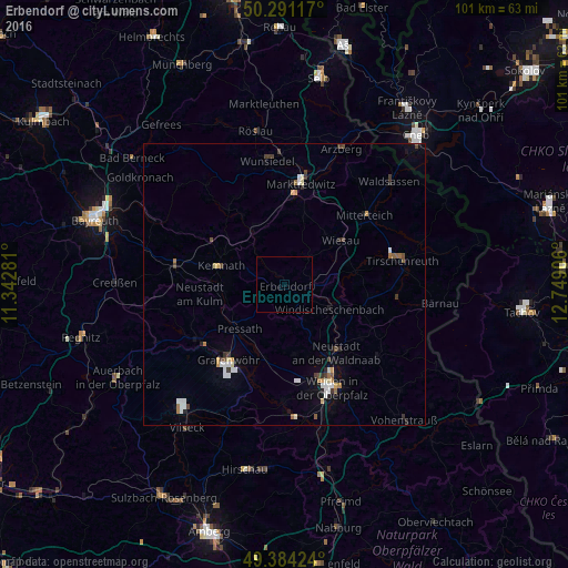
Analysis of Erbendorf night lights 2016
Square area 10x10 km:
 0%
0%90-99
0%80-89
0%70-79
0%60-69
0%50-59
0%40-49
0%30-39
0%20-29
0%10-19
0%0-9
100%Square area 50x50 km:
0.34%90-99
0.3%80-89
0.18%70-79
0.19%60-69
0.25%50-59
0.12%40-49
0.33%30-39
0.35%20-29
0.22%10-19
0.56%0-9
97.16%Clear (daylight) street map image can be seen on geolist.org.
Map coordinates:
50° 17' 28.2" North, 11° 20' 34.1" East
49° 50' 23.4" North, 12° 2' 45.3" East
49° 23' 3.3" North, 12° 44' 56.6" East
Some cities around Erbendorf sort by population:
• Marktredwitz
18.5 km =11.5 mi,  8°
8°
• Berg
7.4 km =4.6 mi,  112°
112°
• Mitterteich
18.7 km =11.6 mi,  48°
48°
• Grafenwöhr
16.9 km =10.5 mi,  216°
216°
• Speichersdorf
19.3 km =12 mi,  280°
280°
• Neustadt an der Waldnaab
15.2 km =9.4 mi,  141°
141°
• Windischeschenbach
9.1 km =5.7 mi,  118°
118°
• Kemnath
11.6 km =7.2 mi,  286°
286°
2929783 (p: 5,364)
Sources (retrieved 2019-11-25):
» Earth at Night: Flat Maps 2012, 2016