Weissach night lights from space
Night Light of Weissach (Baden-Württemberg) from space (Germany) Src. Average luminocity for 10x10km area is 16.3651% and for 50x50km: 25.5352%.
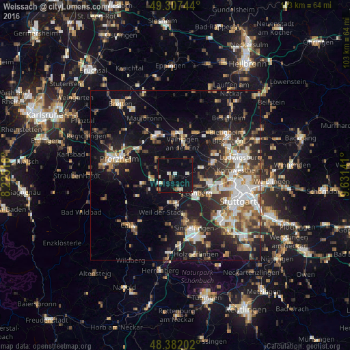
Analysis of Weissach night lights 2016
Square area 10x10 km:
 1.42%
1.42%90-99
3.84%80-89
1.56%70-79
0%60-69
1.14%50-59
0.57%40-49
2.27%30-39
2.27%20-29
2.7%10-19
18.18%0-9
66.05%Square area 50x50 km:
4.17%90-99
4.99%80-89
2.25%70-79
2.79%60-69
3.57%50-59
3.07%40-49
3.51%30-39
3.65%20-29
7.19%10-19
16.13%0-9
48.69%Clear (daylight) street map image can be seen on geolist.org.
Map coordinates:
49° 18' 26.8" North, 8° 13' 30.6" East
48° 50' 48.7" North, 8° 55' 41.8" East
48° 22' 55.3" North, 9° 37' 53.1" East
Some cities around Weissach sort by population:
• Leonberg
8.3 km =5.2 mi,  128°
128°
• Renningen
8.6 km =5.3 mi,  174°
174°
• Rutesheim
4.5 km =2.8 mi,  163°
163°
• Hemmingen
8 km =5 mi,  74°
74°
• Eberdingen
4.5 km =2.8 mi,  36°
36°
• Wiernsheim
7 km =4.3 mi,  305°
305°
• Tiefenbronn
9.6 km =6 mi,  254°
254°
• Heimsheim
6.3 km =3.9 mi,  224°
224°
2812053 (p: 7,712)
Sources (retrieved 2019-11-25):
» Earth at Night: Flat Maps 2012, 2016