Rutesheim night lights from space
Night Light of Rutesheim (Baden-Württemberg) from space (Germany) Src. Average luminocity for 10x10km area is 23.5639% and for 50x50km: 25.8152%.
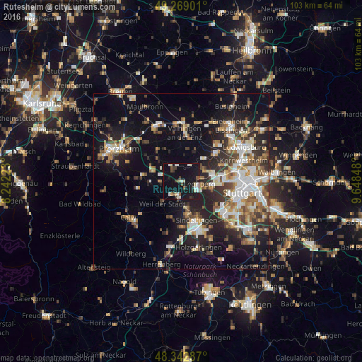
Analysis of Rutesheim night lights 2016
Square area 10x10 km:
 3.27%
3.27%90-99
5.97%80-89
2.13%70-79
0.57%60-69
0.57%50-59
2.7%40-49
2.27%30-39
2.84%20-29
3.13%10-19
41.9%0-9
34.66%Square area 50x50 km:
4.23%90-99
5.01%80-89
2.2%70-79
2.73%60-69
3.64%50-59
3.17%40-49
3.53%30-39
3.98%20-29
7.48%10-19
16.05%0-9
47.97%Clear (daylight) street map image can be seen on geolist.org.
Map coordinates:
49° 16' 8.4" North, 8° 14' 32" East
48° 48' 29.1" North, 8° 56' 43.3" East
48° 20' 34.3" North, 9° 38' 54.5" East
Some cities around Rutesheim sort by population:
• Leonberg
5.3 km =3.3 mi,  99°
99°
• Weil der Stadt
8.5 km =5.3 mi,  219°
219°
• Gerlingen
8.7 km =5.4 mi, 96°
• Renningen
4.3 km =2.7 mi,  186°
186°
• Magstadt
7.2 km =4.5 mi,  167°
167°
• Weissach
4.5 km =2.8 mi,  343°
343°
• Eberdingen
8.1 km =5 mi,  10°
10°
• Heimsheim
5.7 km =3.5 mi,  268°
268°
2842824 (p: 10,222)
Sources (retrieved 2019-11-25):
» Earth at Night: Flat Maps 2012, 2016