Gangelt night lights from space
Night Light of Gangelt (North Rhine-Westphalia) from space (Germany) Src. Average luminocity for 10x10km area is 13.5535% and for 50x50km: 25.0547%.
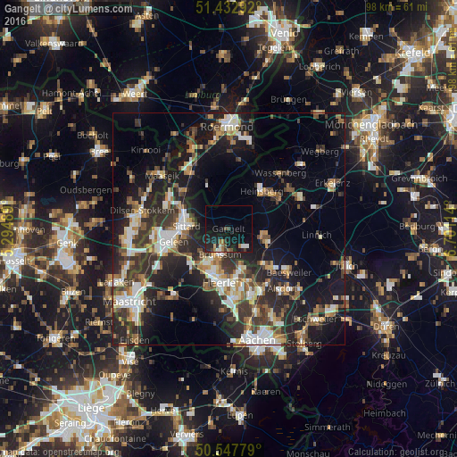
Analysis of Gangelt night lights 2016
Square area 10x10 km:
 0.94%
0.94%90-99
2.27%80-89
0.53%70-79
0.13%60-69
3.61%50-59
0.8%40-49
1.6%30-39
1.87%20-29
4.41%10-19
20.45%0-9
63.37%Square area 50x50 km:
3.3%90-99
4.62%80-89
2.36%70-79
2.56%60-69
3.14%50-59
3.55%40-49
3.86%30-39
5.04%20-29
9.22%10-19
16.79%0-9
45.56%Clear (daylight) street map image can be seen on geolist.org.
Map coordinates:
51° 25' 58.5" North, 5° 17' 41.6" East
50° 59' 32.9" North, 5° 59' 52.9" East
50° 32' 52" North, 6° 42' 4.1" East
Some cities around Gangelt sort by population:
• Sittard, NL
9 km =5.6 mi,  274°
274°
• Heinsberg
10.6 km =6.6 mi,  41°
41°
• Geleen, NL
12 km =7.5 mi,  260°
260°
• Brunssum, NL
5.4 km =3.4 mi,  200°
200°
• Geilenkirchen
8.8 km =5.5 mi,  108°
108°
• Übach-Palenberg
12.1 km =7.5 mi,  133°
133°
• Hoensbroek, NL
9.2 km =5.7 mi,  213°
213°
• Waldfeucht
8.2 km =5.1 mi,  355°
355°
2922722 (p: 11,484)
Sources (retrieved 2019-11-25):
» Earth at Night: Flat Maps 2012, 2016